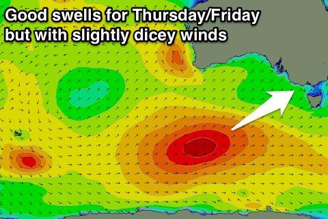
Good end to the week with slightly dicey winds
Victoria Forecast by Craig Brokensha (issued Monday 18th January)
Best Days: Tuesday morning both coasts, Wednesday morning east of Melbourne, Thursday and Friday mornings both coasts, Saturday and Sunday mornings Surf Coast
Recap
Lingering SE winds into Saturday created poor conditions with easing 2-3ft sets on the Surf Coast and around the 4ft range on the Mornington Peninsula.
Sunday started real slow with tiny waves on the Surf Coast and clean small 2ft sets on the Mornington Peninsula.
A new SW groundswell started to kick through the day, best through the middle of the day before the sea breeze kicked in.
Today was much better with the swell easing from 2-3ft on the Surf Coast and a clean pumping 3-5ft on the Mornington Peninsula with offshore winds.
This week (Jan 19 - 22)
Today's swell is expected to be smaller tomorrow, but a reinforcing SW groundswell should keep inconsistent 2ft sets hitting the Surf Coast with 3-4ft waves on the Mornington Peninsula.
N'ly winds that were forecast on Friday now look to be more variable and tending slight W'ly. This will favour the Surf Coast slightly more than the Mornington Peninsula, but both coasts should be fun before weak afternoon sea breezes kick in.
 Wednesday should see light variable winds again as a tricky surface trough lingers across the region but the surf will be small to tiny on the Surf Coast and best to the east with inconsistent 3ft sets on the Mornington Peninsula.
As touched on most of last week, a strong polar frontal progression that's been tricky to forecast for the most part, has continued to play out in our favour.
An initial vigorous polar front has fired up south-west of WA, with a pre-frontal fetch of W/NW gales being followed closely by a secondary fetch of post-frontal W/SW gales while projecting north-east towards us this evening.
This progression will then be followed by a secondary system firing up to our south-west during the middle of the week, generating an additional fetch of SW gales on an already active sea state.
Two good pulses of SW groundswell should result, the first kicking later Wednesday and peaking Thursday to 3-4ft on the Surf Coast and 6ft to possibly 8ft on the Mornington Peninsula.
The secondary system will produce a secondary reinforcing SW swell for Friday more in the 3ft+ and 6ft+ range respectively across both coasts.
Conditions on Thursday are a little dicey with a lingering and light to moderate SE'ly likely in the wake of an evening change Wednesday, while Friday morning should see more variable breezes. We'll confirm this on Wednesday.
This weekend onwards (Jan 23 onwards)
Into the weekend, another smaller reinforcing W/SW swell is due to fill in Saturday, generated by a weaker front pushing un under the country late week.
This won't offer any more additional size and really just slow the easing trend through the weekend.
At this stage early W'ly winds are due to give into an S/SW change Saturday, favouring the Surf Coast, with similar conditions and winds into Sunday. More on this Wednesday.


Comments
Hey Craig,
Thanks for your awesome forcast notes just wondering why most of surf websites including swellnet forcast for torqauy tomorrow has it being onshore whereas your saying it will be variable tending westerly. Do you still think it will be offshore tomorrow and will it be offshore till after midday
Cheers
This is where these notes come into their own.
Looking at automated forecasts won't pick up these variable or locally offshore winds.
The wind gradient is light enough that winds should be variable and likely very light offshore across some spots tomorrow morning.
That changed came through morn pen just before 4. Pretty strong from the west. Lasted about 10 mins before SE seabreeze overpowered it. How does that occur?
Just in time for knockoff. Bugger