Tuesday and Wednesday morning the pick
Victoria Forecast by Craig Brokensha (issued Friday 6th February)
Best Days: Saturday exposed breaks, Tuesday morning east of Melbourne, Wednesday morning
Recap
Poor conditions yesterday with onshore winds and small to tiny amounts of swell, while today winds tended offshore for the Mornington Peninsula but there swell was still really slow and only around 2ft with the odd bigger one.
This weekend and next week (Feb 7 - 13)
The weekend will see a continuation of average to poor surf across the state, with tomorrow due to be clean but tiny on the Surf Coast. The Mornington Peninsula and other exposed breaks will be the pick with a small inconsistent 2ft of swell, kicking a little into the afternoon/evening to 3ft on the sets as a long-range SW groundswell fills in. The morning offshores may tend variable into the afternoon/evening so keep an eye on local winds observations for a late afternoon surf.
Sunday should see more size as the SW groundswell peaks but an early morning onshore change will bring fresh S/SW winds to both coasts creating poor conditions.
Monday will be another day to miss as winds linger from the S/SE early before tending more variable through the mid-late morning. Conditions won't be great though with the overnight onshores creating lots of lump and wobble with an easing swell from the 3ft+ range on the Mornington Peninsula.
 Tuesday looks like the pick of the week as we see a new SW groundswell filling in under offshore N'ly winds.
This swell will be generated over the weekend by a broad but not overly strong polar frontal system, becoming strongest just to our south-west before passing under Tassie.
The Surf Coast should build to an inconsistent 2ft to occasionally 3ft with 4-5ft+ sets across the Mornington Peninsula. The beachies will be the pick under morning NE winds ahead of fresh SE afternoon breezes.
Wednesday morning will see a mix of easing W/SW swell and a period of variable winds early should create clean conditions across both coasts ahead of a shallow S/SW change. A new long-range W/SW groundswell is due into the afternoon though ahead of a secondary medium-range pulse Thursday.
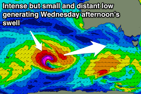
The long-range swell should be generated by an intense but small polar low firing up south-west of WA over the weekend, tracking east-southeast while weakening and breaking down along a line south of Albany.
A very inconsistent but good groundswell should result, building to 2ft to occasionally 3ft on the Surf Coast and 4-5ft+ on the Mornington Peninsula but with those onshore winds.
The secondary swell will be generated by a weaker but broader frontal system firing up on the tail of the original front and pushing more east through our swell window and to about the Bight. This should produce a more consistent swell for Thursday, building to 2-3ft on the Surf Coast and 4-6ft on the Mornington Peninsula through the afternoon (smaller early).
Winds will unfortunately be poor and onshore from the S'th tending SE Thursday with the possibility of more variable winds Friday morning. We'll review this again Monday though. Have a great weekend!

