Average wind and swell outlook
Victoria Forecast by Craig Brokensha (issued Monday 15th September)
Best Days: Possible small window of variable winds at some stage tomorrow morning, Wednesday morning west of Melbourne for desperate surfers
Recap
The weekend was great across the Surf Coast with a reinforcing W/SW groundswell providing 3ft+ waves through Saturday with offshore tending variable winds, while the swell eased from a clean 3ft Sunday morning. The Mornington Peninsula was bigger and in the 5-6ft range with good conditions each morning for the Flinders region.
This morning we're in between swells and with unfavourable E'ly winds favouring locations east of Melbourne compared to the west. A very inconsistent long-range W/SW groundswell should fill in through the afternoon though and reach 3ft across most locations west of Melbourne with bigger bombs at swell magnets, and 6ft+ on the Mornington Peninsula but conditions will be average as winds swing more E/SE and freshen.
This week and weekend (Sep 16 - 21)
Tomorrow will be a day to miss as today's very inconsistent increase in long-range W/SW groundswell eases through the day and winds go funky as a surface trough moves in from the west. SE tending SW winds are most probable but there's a very slim chance of variable winds in between the swing in winds from the east to west.
Wednesday morning will be clean on the Surf Coast with a morning NW'ly but there isn't expected to be much size left with very inconsistent 2ft sets across exposed spots. In any case a strong W/SW change will move through late morning, writing off the surf for the rest of the day.
Behind this change though an increase in long-range W/SW groundswell and is due mixed in with some close-range SW swell from the front as it pushes up into us.
The Surf Coast should build to 3ft through the afternoon with 5-6ft sets on the Mornington Peninsula, with larger and messier 3-4ft and 6ft+ waves Thursday under fresh to strong SW winds.
Unfortunately winds look to remain poor on the backside of the swell into Friday with the frontal system pushing across us Wednesday, stalling east of Tasmania directing S'ly winds into us.
The low will take a while to move off and this will probably result in lingering onshore winds Saturday before swinging more to the east into Sunday.
 No new swell is due until later Saturday (easing Sunday) and this will be a long-range and inconsistent SW groundswell. Exposed spots on the Surf Coast aren't expected to get above 2-3ft with 4-5ft+ sets on the Mornington Peninsula. Sunday will be the day to surf east of Melbourne with those E/NE winds and dropping swell.
Next week onwards (Sep 22 onwards)
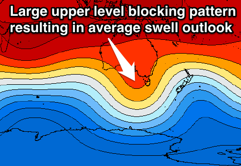
Longer term we still have to rely on long-range W/SW groundswell energy from the Southern Indian Ocean which isn't ideal. This is due to a large blocking pattern setting up across the Bight, deflecting frontal systems away from us. Check back here on Wednesday for the latest on this though.


Comments
Craig
Just quickly... i'm slightly confused. I'm reading E/NE winds for sunday but seeing W/SW?
Am i running with what i read or see?
Sarge
Yep, the outlook has changed a little with that ridge of high pressure moving in from the west slowing down a little.
So likely SW across most regions Sunday (W/NW on the Surf Coast for a period during the morning).
Thanks Craig
Such a frustrating back end to winter!!
Isn't it!
But what a terrible winter it was as well.
Since the swell that hit the Bells contest, there were only a couple through your prime season for the Surf Coast.
Now you're getting average swells but poor winds for spots that would be enjoying the smaller stuff. Frustrating.
Should have just stayed in indo for the winter! i've given up even reading the indo forecast, it hurts to much....