Fun swells/favourable winds for more exposed locations
Victoria Forecast by Craig Brokensha (issued Monday 21st July)
Best Days: Every morning over the coming days, more east of Melbourne from Thursday onwards
Recap
Saturday was average across the state with lingering onshores and a good easing swell from Friday, while Sunday was the pick of the weekend with morning offshores and a fun easing 2-3ft of swell across the Surf Coast.
Today an expected kick in good SW groundswell has come in right on cue with clean 3-4ft surf west of Melbourne and 6ft+ sets on the Mornington Peninsula under light local offshores. The swell should ease a touch through the day as winds tend E/NE.
This week and weekend (Jul 21 – 27)
Today's swell should ease into this afternoon and further tomorrow from 2ft around Torquay and 2ft to occasionally 3ft at 13th Beach and 3-5ft on the Mornington Peninsula. Winds will play out similar to today with clean conditions across both coasts with local offshores that should tend variable into the afternoon, creating a full fun day of surfing.
Wednesday should see similar sized waves to Tuesday morning as a small to moderate sized and inconsistent SW groundswell fills in. Good conditions are again expected across both coasts through the morning with local offshore tending NE winds.
A slow drop in size is then due into the end of the week as morning N'ly winds favour locations east of Melbourne as the swell becomes smaller.
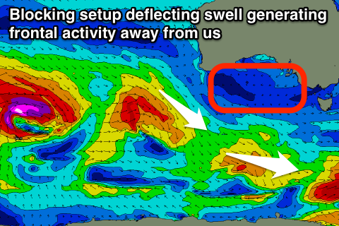
 As touched on last update the models were divergent regarding the development of a strong frontal progression under the country and towards us through the end of the week, and unfortunately they settled with ECMWF's forecast of a weak and unsubstantial surface trough moving in slowly all week, effectively setting up a weak blocking pattern across our swell windows (right).
What this will result in is no real decent swell for us at all through the end of the week or into the start of the weekend.
What we'll have to rely on is long-range and very inconsistent W/SW groundswell energy, with the best pulse due through Sunday morning.
At this stage this pulse doesn't look to offer much above 2ft+ on the Surf Coast and 3-5ft sets on the Mornington Peninsula but N/NW tending NW winds should create workable conditions across both coasts.
Longer term we may see some better W/SW groundswell into next week, but we'll review this Wednesday.


Comments
Hey craig. I'm moving to melbourne in october, and phillip island will be the closest thing i have to a "local" spot. When would you say are the best surf periods of the year generally? I bodyboard, so short reef breaks are also an option. Im coming From the sunny coast/brisbane so im hoping to see more consistency in terms of size and quality?
Warhawk Phillip Island has no waves mate, pretty much flat with shit winds;)
Watch out for Matty the local, fierce cunt will drop in on you fade ya and let your tyres down and your girl friend well thats another story.......
Hi WarHawk.
Consistency wise you'll hardly get a flat day over on Phillip Island, it's just the winds you have to work around.
Any small to moderate sized swell with winds from the E to N/NW there's plenty of options from the beaches to reefs.
A couple of spots handle the NW'ly but you need more swell for them to get going and then any winds further around from west towards the south-west there's nothing really to surf. Large swell and S-SE winds opens up a few options, but enough said.
Well...... looks like a monster low for vicco S.A next week...... I'm talking serious monster low....
Bit more info here SD, but not too much: www.swellnet.com/reports/forecaster-notes/victoria/2014/07/23/beaches-east-until-friday-surf-coast-monday
Also wouldn't be going over the top re monster low, just a series of real intense polar lows/fronts. Something we haven't seen for a while in Vicco.
Craig - 1200 tues. 29/7...... 944hpa..... Looking pretty serious to the nth and nw of it....
http://www.metvuw.com/forecast/forecast.php?type=rain®ion=swp&noofdays=7
Totally, but a monster low to me would signify something much more serious, ie a bombing system with wind speeds in storm-force range. This is a very strong system but nothing out of the ordinary. Hopefully finally some decent swell above 6ft with offshores for the Surf Coast.
Cheers.....But I'd hate to be on a long liner... lol
Definitely.