Great east of Melbourne Tuesday, back to the west from Wednesday
Victoria Forecast by Craig Brokensha (issued Monday 14th July)
Best Days: Tuesday, Wednesday onwards west of Melbourne
Recap
A brief window of workable conditions was seen around Torquay Saturday morning with a building swell, but winds swung onshore by 8am, writing off the surf for the rest of the day.
The swell peaked overnight, but Sunday offered good waves as winds tended offshore and the swell eased from 4ft around Torquay and 3-5ft at 13th Beach. The Mornington Peninsula saw large surf but conditions were poor with fresh W'ly winds.
Today a reinforcing SW groundswell has kept the Surf Coast up around the 3-4ft range with light offshore winds, while the Mornington Peninsula was a lot cleaner but a touch too big and in the 6ft range. We should see conditions straighten out through the day as winds tend light NE and the swell eases a touch.
This week (Jul 15 – 18)
Today's reinforcing SW groundswell will ease into this afternoon and bottom out tomorrow morning, but a new W/SW groundswell is due to fill in through the afternoon. This has been generated by a fetch of gale to severe-gale pre-frontal W/NW winds through our swell window over the weekend and should pulse the Surf Coast back to 3ft+ during the afternoon with 4ft sets at 13th Beach and Bells/Winki. The Mornington Peninsula should build from 3-5ft through the morning to 6ft+ into the afternoon and strengthening N/NE tending N'ly winds favour locations east of Melbourne and the beaches to the west.
Tomorrow's increase in W/SW groundswell will be the first in a series of strong W/SW groundswell pulses, with a drop back in size due Wednesday morning ahead of the arrival of the secondary pulse Wednesday afternoon.
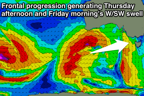
The source of these swells is an amplification of the Long Wave Trough moving east from the Southern Indian Ocean, directing a series of vigorous polar fronts on a track just west of where it is focussed. With the LWT currently over South West WA, the polar fronts are being steered up towards WA, and through our western swell window.
This has occurred through the weekend, with a flurry of severe-gale W/SW winds being generated through our far western swell window. As the LWT moves through the Bight over the coming days so will the frontal activity, with an initial long-range W/SW groundswell pulse due Wednesday afternoon ahead of a bigger and more consistent increase Thursday, peaking through the afternoon.
 Size wise we should see the Surf Coast becoming more consistent in the 3ft range Wednesday afternoon, with a touch less size early, with the Mornington Peninsula increasing to 6ft. Winds will be fresh from the N/NW all day, favouring the Surf Coast over locations east of Melbourne.
Thursday's increase should be to a larger 3-5ft across the Surf Coast into the afternoon and 6-8ft+ on the Mornington Peninsula and winds. The Surf Coast will offer the best waves again as morning W/NW winds give way to an afternoon W/SW change.
Thursday afternoon's increase in W/SW groundswell should hold a similar size into Friday morning before easing a touch, but this will be softened by a smaller reinforcing SW swell linked to Thursday afternoon's change. Winds don't look as good as Thursday though, with only a short-lived W'ly around Torquay early and fresh SW winds everywhere else.
This weekend onwards (Jul 19 onwards)
Moderate levels of SW swell should persist through the weekend, easing on the back of Friday afternoon's pulse into Saturday, while Sunday is a little undecided with the models diverging on the strength of a cold outbreak pushing up through the Tasman Sea along the East Coast over the weekend. With this divergence we're either going to see poor onshore waves Sunday, or a period of early W'ly winds on the Surf Coast, but either way, options will be limited.
Check back here Wednesday for more on how the weekend and next week is panning out.

