Eight swell sources this week, not much above two foot, but the long term outlook is great

Sydney, Hunter and Illawarra Surf Forecast by Ben Matson (issued Monday 4th February)
Best Days: Small peaky surf most days this week, biggest Thurs/Fri ahead of a slow building trend over the weekend. Solid E/NE swell from Sunday afternoon through the first half of next week.
Recap: A strong short-range E’ly swell provided strong surf over the weekend, with sets reaching 4ft+ on Saturday, before easing from 3ft+ on Sunday. Winds were mainly light and variable so conditions were clean ahead of the afternoon sea breezes. A smaller mix of leftover E’ly swell and new NE windswell has been accompanied by light variable winds today, creating clean conditions. A small S’ly swell may be present in the water but it’s not showing up across any of the buoys as yet.

Chunky E'ly swell at Manly over the weekend
This week (Feb 5 - 8)
Today’s Forecaster Notes are brought to you by Rip Curl
I'm not expecting much for the rest of the working week, just a series of small swells glancing the coast from various regions.
In fact, I have counted eight individual swell sources that will contribute varying levels of small swell for Southern NSW over the next four days.
Model guidance has a small long period S’ly swell pegged for today though we’re not seeing much (if anything) right now so I’m not holding out hope for tomorrow - just a few stray waves if we're lucky.
The NE fetch responsible for today’s small windswell hasn’t restrengthened this afternoon as much as models expected, and it’s forecast to retreat overnight, which means small weak swells for Tuesday too.
Another strong front is passing below Tasmania today though it’s poorly aligned for our region so we won’t see much size, just a foot or two of southerly swell glancing the coast through the middle of the week.
The trades are active across the Northern Tasman Sea, though they’re poorly aligned for our region so we’ll see only small surf for the next few days, up to a slow, inconsistent 2ft at exposed beaches with long breaks between the sets. A little more size is likely later in the week thanks to a slight broadening, strengthening trend but I’d be surprised if we saw much more than 2ft, maybe 2-3ft through Thursday (more likely the afternoon) and Friday.
A small ridge will develop east of Bass Strait on Tuesday, but remain south of about Ulladulla’s latitude. This means the most size we’ll see from this source (building to 3ft+ later Tuesday, holding Wednesday easing Thursday) will be found across the Far South and, at a pinch, the South Coast, with smaller surf north from the Illawarra. Some locations across the Sydney reigon may see stray 2-3ft sets through this period but for the most part 2ft seems to be a reasonable estimate.
Model guidance has cooled on the long period S/SE swell for Wednesday (mentioned in Friday’s notes), and the weekend’s satellite passes didn’t pick up anything worthwhile either. We’re seeing some small numbers in the model mix around Wednesday evening but I doubt it’ll show much size across the coast.
And lastly, a small but strong E’ly fetch will develop west of Cook Strait (the body of water separating New Zealand’s North and South Islands) on Wednesday afternoon. Unfortunately the fetch length is expected to be very short, but it’s plausible that we’ll see a small pulse of E’ly swell from this region later Friday. Truth be told, it’ll be impossible to discern from the aforementioned small rise in trade swell anyway.
Actually, that’s not the last swell source. Local winds will be light and variable with sea breezes Tuesday, Wednesday and Thursday but the NE breeze will strengthen a little more prominently into Friday, generating a small NE windswell into the mix.
Did I really need to go into such detail about eight different swell trains, only one of which may exceed two feet in size? Not really, but it’s always worth keeping a tab on what’s coming in case there are upgrades (or downgrades) in future updates.
This weekend (Feb 9 - 10)
The slight pulse in trade swell later this week will hold into the weekend, and with a weak synoptic pattern across the coast we’re looking at some fun waves.
In fact, the tale end of these trades are expected to become somewhat supercharged as a series of tropical lows (and possible tropical cyclones) feed in from the north. This will create a bigger round of longer period E/NE swell arriving some point on Sunday and peaking into the start of the new week.
At this stage I’m expecting Saturday and early Sunday to offer inconsistent 2-3ft+ sets at reliable swell magnets up and down the coast, with a possible Sunday afternoon increase into the 3-5ft range.
Also in the mix this weekend will be a small mid-range south swell originating from a poorly aligned but broad fetch tracking south of Tasmania on Thursday and Friday (also holding position over the weekend). It’s a nice looking onion on the charts but I don’t think we’ll see much more than 2-3ft from this source at reliable south swell magnets.
Anyway, I’d highly recommend putting some time aside this weekend as we’ll see good beachbreak surf across most coasts both days under a light and variable wind regime.
Next week (Feb 11 onwards)
The weekend’s small S’ly swell should continue through Monday and Tuesday though no great size is expected. I’ll be stoked if it produces 2-3ft surf at reliable south facing beaches.
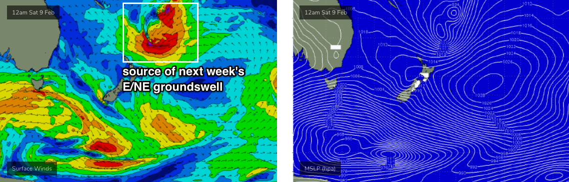
The South Pacific synoptic charts look very juicy as a strong passage of intense tropical storms push soutwards through the waters between Samoa and Fiji, enroute to New Zealand (which is gonna cop one heck of a run of very large N, NE and E/NE swell from this weekend onwards).
The main concern I have at this stage is that as these systems consolidate into a single sub tropical low (see chart below), they’ll eventually move in behind the swell shadow of New Zealand. As such, most of our surf potential will be reliant on an impressive number of very strong but not optimally consolidated fetches moving perpendicular through the swell window. Being located quite some distance from the mainland, we have to be cautious as to its potential.
Anyway, right now I think we’re looking at two or three days (Mon/Tues/Wed) seeing solid E/NE swell in the 3-5ft range, with an embedded pulse somewhere in the middle - probably late Mon or early Tues - that'll punch another foot or so above this (say, 4-6ft). Let’s see how Wednesday’s model runs are looking.
Comments
Finally something exciting to look forward to, lets hope the current models are telling the truth
It’s probably just running hot this far out on the models, and will get downgraded to junk again later on :)
Iv just committed to study next week, no doubt it will b good those days!!!!!!!