Plenty of swell ahead, solid early-mid next week

Sydney, Hunter and Illawarra Surf Forecast by Ben Matson (issued Wednesday 3rd May)
Best Days: Thurs/Fri: fun clean south swell with mainly light winds (just a posisble lingering onshore north of Sydney early Thurs). Mon, maybe Tues: strong south swell with likely good winds. Later Tues/Wed: windy conditions developing, but very large surf from the south. Next week: small building E/NE swell all week that could possibly become solid later in the week.
Recap: Tuesday was tiny. Today we’ve seen building short-range S’ly swells in the lee of a southerly change, up to 3ft at south facing beaches though much smaller elsewhere due to the direction. Certainly not very high quality either thanks to the southerly breeze.
This week (May 2 - 5)
The current southerly change will clear to the northeast overnight, leaving most regions under a light variable flow for Thursday and Friday as a ridge of high pressure moves in from the west.
There is a risk of a lingering S’ly breeze north of Sydney on Thursday morning but other than that we should see a gradual improvement in surf conditions.
The swell trend will remain out of the southern quadrant for the next few days, and surf quality should improve quite a bit as we see mid and long range sources impact our coast. Due to the large travel distances and relatively low core wind speeds, no great size is expected however we should see a mid-range S’ly swell (originating from the post-frontal S/SW fetch east and south of Tasmania) kick up 3ft sets at south facing beaches throughout Thursday.
It won’t be anything amazing, and some locations may see a slight cross wobble from today’s winds, but it should be workable. Expect smaller waves at locations not directly open to the south (the Hunter may see a few bigger waves though).
On Friday, a small but longer period S’ly swell - originating from the parent polar low to this frontal progression, well south of Tasmania on Monday - will make landfall. Set waves will be much less consistent than Thursday’s swell (which will be easing by this time) but should be stronger and more defined, occasionally cracking the 3ft mark at south facing beaches (bigger in the Hunter, but smaller elsewhere).
Light variable winds are expected on Friday so this is certainly the pick of the short term forecast period.
This weekend (May 6 - 7)
No change to the weekend’s forecast. Friday’s south swell will ease through Saturday so apart from the early morning - where south facing beaches may see occasional 2ft+ sets (slightly bigger in the Hunter) - we’re looking at small, weak leftovers.
Light N’ly winds Saturday will swing W’ly and freshen on Sunday as a deepening cut-off low forms east of Tasmania. So expect very small clean waves for the second half of the weekend.
As mentioned in Monday’s notes, there is still a chance that we could see a late kick in new S’ly swell on Sunday afternoon, originating from one of my favourite, rare south swell windows - the waters immediately east of Bass Strait. The aforementioned cut-off low looks like it’ll display gale to storm force winds in this region at some point.
However current model guidance suggests these winds won’t develop properly until some time on Sunday morning which probably means an arrival (across the Sydney region) overnight Sunday.
I’ll keep an eye on this in Friday’s notes though, int he event that the models bring it forward six hours.
Next week (May 8 onwards)
No change to the longer term outlook either - I’m still keeping a watchful eye over the SW Tasman Sea and the Lower Coral Sea.
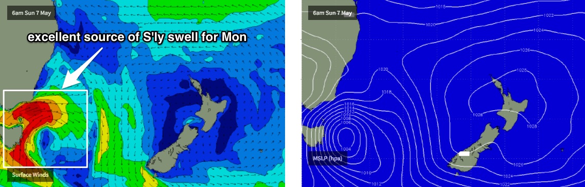
The developing low east of Bass Strait some time on Sunday should generate a couple of days of tricky though solid south swell for Southern NSW. I’ve used the words “tricky” because the close proximity of this system to the mainland - coupled with a slightly erratic model output - means that confidence is not yet high on how much, how long or how good the associated surf will be.
Early indications suggests some flukey south swell building through Monday in the 4-5ft range with reasonably good local winds (bigger surf in the Hunter around 6ft+), before a strong southerly fetch pushes northwards along the coast into Tuesday and delivers a larger but more wind affected round of south swell through into Wednesday that could reach 6-8ft at most south facing beaches.
There’s likely to be several windows of favourable winds throughout this period, as slow moving low pressure systems like this often undergo cycles whereby small-scale features move around the low, tweaking the winds within 90 degrees for hours at a time. But, this won’t be properly understood until much closer to the time. So I’ll reevaluate in more detail on Friday.
Elsewhere, we have a tropical cyclone looming for the Vanuatuan region later this week, in fact it is expected to remain (unusually slow moving from about Thursday until Sunday or Monday - this could wreak havoc across the country).
As for surf potential, the cyclone is expected to remain inside the swell shadow of New Caledonia but a strong ridge to the south-east is expected develop over the weekend, cradling the cyclone and building E/NE swells that should start to building slowly across Southern NSW early-mid next week, ahead of a possible solid E/NE pulse mid-late next week. This is still some time away though and will require close evaluation in Friday’s and Monday’s notes.
So.. lots of exiting surf in the long term, just a few days of mediocre but improving waves before then.
See you Friday!