Clean each morning, south swell magnets the go
Sydney, Hunter and Illawarra Surf Forecast by Guy Dixon (issued Monday 28th March)
Best Days: Each morning, otherwise Wednesday and Saturday if you have the afternoon off.
Recap:
Much of the weekend was dominated by easterly and southerly energy, with options between 3-4ft. The early mornings were the only opportunity for a decent wave, before seabreezes set in.
We woke to a fresh southerly pulse this morning, with exposed south facing beaches seeing sets up to 5ft, larger across the Hunter. Without an established offshore breeze early, conditions remained lumpy but workable into the late morning.
This week (Tuesday 29th - Friday 1st):
Today’s southerly pulse has started to fade, and will continue to do so into the evening. Reinforcing southwesterly fetches with weak frontal activity during the weekend are will provide a small pulse of southerly groundswell to around 3ft+ across south facing beaches by Tuesday morning.
A smaller and less favourably aligned southwesterly fetch has been passing over the Southern Ocean throughout today and is expected to maintain a small amount of southerly energy across the magnets on Wednesday, with options in the 2ft range.
Meanwhile, east/northeasterly trade energy is due to slowly fade from the 2ft+ range on Monday, further on from the 2ft range on Tuesday and Wednesday.
Early southwesterly breezes will clean surface conditions up, before tending southeasterly later on Tuesday, while offshore breezes look to persist throughout Wednesday, leading to plenty of clean options no matter what time you start work.
A low pressure trough looks to deepen inland throughout Tuesday, before moving offshore on Wednesday with an embedded low expected to develop within. A very small and brief northeasterly fetch looks to set up ahead of this system, but not enough for any substantial swell generation.
An associated easterly trade fetch located further to the north and east looks to steer an easterly trade-flow towards the NSW coast from around Wednesday (northeasterly fetches look to develop further north in the days prior, although very small and distant so size looks negligible).
The airflow will gradually swing northeasterly as the trough shifts further offshore, with an embedded low developing within.
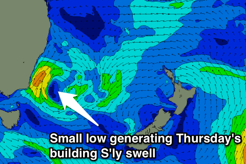
 As this low develops, south/southwesterly fetches along the southwestern quadrants of this system look to increase, remaining virtually stationary from Wednesday evening until Thursday morning.
As a result, a short range southerly windswell looks to increase, peaking on Thursday afternoon in the 3-4ft range across south facing beaches, fading from the 3ft+ range on Friday.
A second pulse of long range southerly groundswell looks to peak on Friday afternoon with inconsistent sets in the 2-3ft range generated by a poler low southwest of WA.
Finally, an easterly fetch located to the south of Tahiti has the potential to generated easterly groundswell for Thursday. While the models are showing good numbers, this energy looks to be largely shielded by New Zealand. The NSW coast would be lucky to see very inconsistent sets in the 2ft range.
The early mornings hold the best chance of a clean wave, likely tending onshore as the late morning wears on.
This weekend (Saturday 2nd - Sunday 3rd) and next week (Monday 4th onward):
Each swell window looks to settle down leading into the weekend, with the exception of long range east/northeasterly trade swell providing inconsistent sets ebbing and pulsing near 2ft.
A brisk change is due to move through on Saturday evening, whipping up a short range southerly windswell to around 3ft+ on Sunday across south facing beaches, fading from around 2ft on Monday.
Ahead of the change, Saturday is looking good for a clean wave, with west/northwesterly breezes persisting for a good portion of the day. Following the change on Sunday however, options will be limited to southern corners where the swell size will be significantly smaller.

