Make the most of Sunday

Southern Tasmanian Forecast by Craig Brokensha (issued Friday January 10th)
Best Days: Sunday morning
Features of the Forecast (tl;dr)
- Small, inconsistent W/SW groundswell for Sun (possibly a touch undersized early) with N/NE winds, shifting E/NE late AM then S-S/SE
- Easing swell Mon with mod-fresh S winds
- Tiny Tue with light S winds, increasing
- Tiny W/SW groundswell Wed PM and Thu
- Strong NE winds Wed, W/NW tending strong S Thu
Recap
Conditions were clean but tiny yesterday, similar this morning but with a touch of east in the offshore wind.
This weekend and next week (Jan 11 - 17)
Tomorrow will remain tiny but into Sunday and Monday, our W/SW groundswell is on track.
The source, discussed earlier this week, was a strong, slow moving low to the south-west of Western Australia and this low is now breaking down to the south of that state.
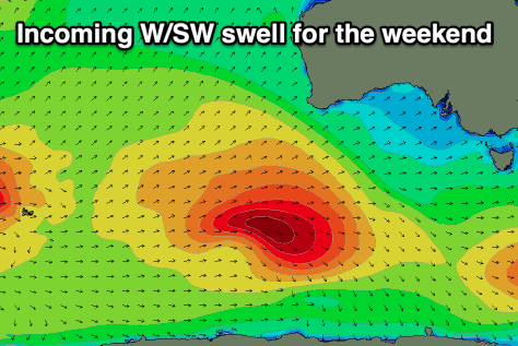
We should see inconsistent but good 2ft sets across Clifton on Sunday, possibly a touch undersized at dawn, easing back from a similar size on Monday.
Local winds are only favourable Sunday morning and out of the N/NE, shifting E/NE later morning and then S/SE into the afternoon as a trough moves through.
Monday is now a no go with lingering, moderate to fresh S’ly winds across the South Arm, lighter Tuesday but with a tiny, fading swell.
Now, into Wednesday afternoon and Thursday, a very long-range and inconsistent W’ly groundswell is due, but the source was so far away (southern Indian Ocean) that we’ll be unlikely to see much over 1ft.
Strengthening NE winds on Wednesday feeding into a low to our west will then shift strong S later morning Thursday as the low moves across us.
This low looks to deepen off the Gippsland Coast bringing stormy swell to the East Coast with small onshore surf for us. Check back here on Monday for confirmation though and have a great weekend!