Small to tiny run continues
Southern Tasmanian Forecast by Craig Brokensha (issued Wednesday December 18th)
Best Days: Tomorrow morning for the desperate, Sunday morning
Features of the Forecast (tl;dr)
- Tiny mix of swells easing tomorrow with variable tending strong S/SE
- Tiny Fri with fresh NNE tending strong E/NE winds
- Building, small W/SW swell Sat, holding Sun through Mon and Tue
- Mod-fresh SW tending strong S winds Sat, NW tending variable ahead of E/NE breezes Sun
- Strong S/SW-SW winds Mon/Tue, S Wed
Recap
Tiny surf yesterday has given way to a mix of long-range groundswell and localised windswell building today, 1-1.5ft and clean this morning but now a mess.
This week and weekend (Dec 19 - 22)
Today’s mix of swells are expected to ease back from 1-1.5ft tomorrow morning with variable winds that might be lingering S’th at dawn but will improve through the morning ahead of sea breezes.
Friday looks even tinier and with a fresh N/NE tending stronger E/NE breeze.

The weekend will start tiny, but into Saturday afternoon/evening and more so Sunday, some new W/SW swell is due and this might come in at a better 1-2ft across Clifton.
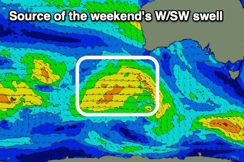
The source is a healthy frontal progression that’s currently south-west of WA and will move east, under the country over the coming days.
Winds on Saturday as it builds look poor and moderate to fresh from the SW tending strong S’th with Sunday seeing NW winds, tending variable ahead of E/NE sea breezes.
A secondary system moving in through our swell window over the weekend looks to maintain small 1ft to occasionally 2ft sets across Clifton Monday/Tuesday before easing Wednesday.
Unfortunately a trough linked to the swell generating system looks to bring strong SW-S/SW winds early next week, tending S Wednesday.
Longer term increasing activity may be seen into the end of the year, but more on this Friday.

