Active run of small surf from Sunday
Southern Tasmanian Forecast by Craig Brokensha (issued Friday December 6th)
Best Days: Sunday morning, Monday, Tuesday morning, Wednesday morning, Thursday morning
Features of the Forecast (tl;dr)
- Tiny W/SW swell for tomorrow PM, easing Sun
- N/NE tending S/SE winds tomorrow, gusty W/NW tending W/SW Sun
- Building mid-period W/SW swell Sun, holding Mon AM, easing thereafter
- N/NW tending W/NW winds Mon, NW tending S/SE Tue
- Small W/SW swell later Tue through Fri with W/NW winds Wed, strengthening W/NW tending W/SW winds Thu and S Fri
Recap
Conditions have been excellent the past two mornings but the surf has been tiny and at a low point.
This weekend and next week (Dec 7 - 13)
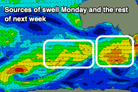
Tomorrow will remain tiny, but into the afternoon and Sunday morning, a tiny W/SW swell is due, generated by a healthy frontal system south of Western Australia mid-week.
1-1.5ft sets are due across Clifton but with N/NE tending gusty S/SE winds tomorrow, with stronger W/NW tending W/SW winds on Sunday.

The frontal system linked to Sunday’s winds now looks a little stronger and with this we should see a healthy increase in mid-period W/SW swell during the day, likely 1-2ft in the morning and 2ft+ later with Monday continuing around 2ft+ before easing through the day.
Trailing frontal activity will then likely maintain 1-2ft sets from later Tuesday through Friday next week.
Coming back to Monday and a N/NW tending W/NW offshore will create clean conditions all day, with NW winds Tuesday ahead of S/SE sea breezes.
A W/NW breeze should persist Wednesday with Thursday seeing strengthening W/NW tending W/SW winds ahead of a S’ly Friday.
Longer term the outlook is quiet so make the most of the coming swell. Have a great weekend!

