Tricky wind outlook thanks to troughy weather
South Tasmanian Forecast by Craig Brokensha (issued Wednesday November 27th)
Best Days: Selected spots Friday afternoon and Saturday morning, possibly later Sunday, Monday morning
Features of the Forecast (tl;dr)
- Strong S/SE winds tomorrow
- Freshening E tending E/NE winds Fri with a building W/SW swell into the PM
- Easing swell Sat with NE tending E/NE winds
- Strong S/SE-SE winds Sun with a jump in SE windswell, with winds tending variable later
- Easing S/SE and SW swells Mon with N/NW tending SE winds
- Small, inconsistent W'ly groundswell building next Wed
Recap
Yesterday was small and clean to 1-2ft but sea breezes kicked in through the day while today was tiny and not ideal with ease in the wind.
This week and weekend (Nov 28 - Dec 1)
Tomorrow is still due to be a lay day as we fall under the backside of a trough, bringing strong S/SE winds to the region.
Unfortunately winds will linger out of the east on Friday as our long-range W/SW groundswell fills in.
This is still expected to reach 2-3ft into the afternoon but with fresh E/NE winds, easing Saturday from 2ft under a NE tending E/NE breeze.
Sunday unfortunately looks poor again with strong SE winds as a low north of the start drifts south, across us.

This will bring a building windswell that could improve on dark as winds back off and go variable.
Size wise it looks 2-3ft or so, easing later and then smaller and to 2ft on Monday but with a N/NW offshore.
Easing surf is then due into Tuesday ahead of a tricky, W/SW groundswell due on Wednesday.
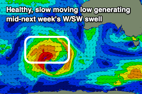
This is set to be generated by a great low forming to the south-west of Western Australia, producing a slow moving fetch of gales while moving through our western swell window. The orientation isn’t ideal and this will rely in small surf likely to 2ft max but we’ll review this on Friday.

