Tricky period of winds ahead
Southern Tasmanian Forecast by Craig Brokensha (issued Monday November 25th)
Best Days: Dawn Wednesday, Saturday morning selected spots
Features of the Forecast (tl;dr)
- Small W/SW swell building tomorrow with early variable tending S/SE winds mid-AM then freshening
- Easing swell Wed with N-N/NE tending E/NE winds
- Strong S-S/SE winds Thu
- Moderate sized, inconsistent W/SW groundswell building Fri, peaking in the PM with freshening E-E/NE winds
- Easing swell Sat with E/NE-NE winds
Recap
Our new swell maintained 2-3ft sets across Clifton on Saturday with favourable winds most of the day, while a trough brought onshore winds yesterday as the swell eased, tiny and onshore again today.
This week and weekend (Nov 26 - Dec 1)
Looking at tomorrow and we’ve got our small pulse of W/SW swell due to fill in through the day, generated by a healthy front moving in from the South West of WA, under the country on the weekend.
There’s no change to the expected peak in size with building sets to 1-2ft due into the afternoon but early variable winds will give way to freshening S/SE winds mid-morning, right as the swell starts building.
Wednesday morning looks cleaner but with fading sets from 1-1.5ft under a N-N/NE tending E/NE breeze.
Thursday will be a lay day thanks to strong S-S/SE winds and a low point in swell, tending more E-E/NE on Friday along with the arrival of a strong new W/SW groundswell.

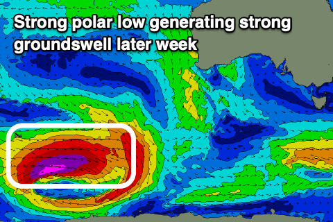
This is being generated by a polar low currently around the Heard Island region, with a fetch of storm-force winds projecting east, producing a decent kick in size to a slow 2-3ft through the afternoon.
Unfortunately, freshening E/NE winds will create unfavourable conditions for most spots, with Saturday seeing E/NE-NE winds opening up a couple more options as the swell fades.
Longer term, a deepening low across us will bring some short-range W/SW swell and W’ly winds into Sunday/Monday along with some background swell energy but to no major size. So all in all not that great of an outlook.

