Tiny run of west swells
Southern Tasmanian Surf Forecast by Craig Brokensha (issued Wednesday July 24th)
Best Days: Today, Sunday morning
Features of the Forecast (tl;dr)
- Tiny surf tomorrow with strong N/NE tending W/NW then weaker N/NW winds
- Tiny Fri with strengthening N/NE winds
- Building SW swell late Sat, easing rapidly Sun
- NW tending W/SW winds Sat, W/NW tending variable Sun
Recap
Monday afternoon’s good increase in W/SW groundswell held into yesterday morning with clean 3ft waves, best through the afternoon.
Today the swell is smaller and with a bit of north in the wind.
This week and weekend (Jul 25 - 28)
The current swell will fade into the end of the week with tiny waves due through tomorrow and Friday, with a little west swell unlikely to generate any size above 1ft.
Conditions will be windy and choppy across Clifton tomorrow morning with a strong N/NE breeze, shifting W/NW into the later morning and then back to the N/NW during the afternoon.

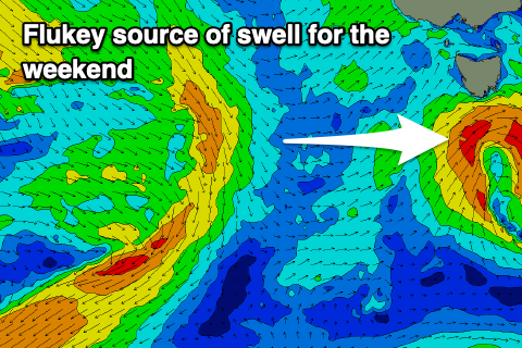
The weekend is a tricky one. A strong but too far north positioned mid-latitude frontal system is due to move in from the west, dipping east-southeast on approach to us while weakening.
All of the swell generating potential will sit too far north of our swell window, but as it tracks south-east on Saturday, a quick fire fetch of SW winds are due to be generated a little better aimed in our swell window.
This may kick up 1-2ft of swell late Saturday, easing rapidly Sunday from a similar size and afternoon W/SW winds look to create bumpy conditions on the former, tending back to the W/NW for Sunday.
Following this the outlook remains very slow so try and make the most of today and the small, weak swell Sunday morning.

