Fun surf from Sunday working the morning winds
Southern Tasmanian Surf Forecast by Craig Brokensha (issued Friday November 10)
Best Days: Sunday morning, Monday morning, Wednesday morning, early Thursday, Friday morning
Features of the Forecast (tl;dr)
- Tiny Sat with strengthening S/SW winds (variable early)
- Small, inconsistent W/SW swell Sun with N/NW winds, tending W/NW late AM and strengthening from the W/SW through the PM
- Moderate sized SW swell Mon with NW tending W/NW winds, then W/SW-SW into the PM
- Stronger, larger SW groundswell building Tue, peaking in the PM with fresh strengthening W/SW tending SW winds
- Easing swell Wed with variable tending S/SE winds
- Smaller Thu with early W/NW tending gusty W/SW winds
- Fun Fri with W/NW tending SW winds
Recap
Bumpy, small surf yesterday morning with average winds in the wake of a trough, cleaner this morning but tiny. Sea breezes are now in, bringing some sea fog with it and creating poor conditions.

Sea breeze bringing in sea fog this afternoon
This weekend and next week (Nov 11 - 17)
The weekend will start tiny and with developing onshore winds as another trough clips us, while come Sunday, a fun, inconsistent W/SW swell is due, generated by a distant but slow moving polar low that formed south-west of Western Australia earlier in the week.
Inconsistent 1-2ft sets are due and winds should be great, N/NW in the morning, shifting strong W/NW later morning and then W/SW later afternoon.
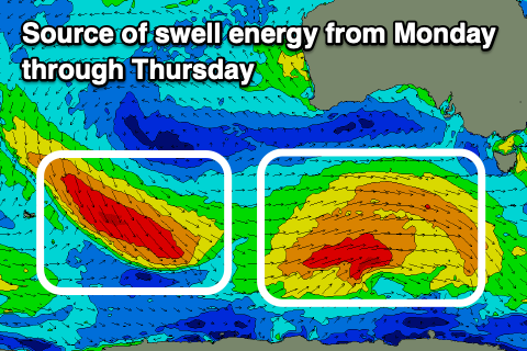
This shift in winds will be associated with a healthy polar low linked to a good pulse of mid-period SW swell on Monday moving under the state.
The low is forecast to form on the polar shelf, south-southwest of Western Australia today, producing a fetch of strong to near gale-force W/SW winds while moving east.
This will generate a good pulse of SW swell for Monday, building to 3-4ft.

Winds look favourable and NW through the morning, shifting W/SW-SW into the afternoon as the next swell producing front clips us.
This secondary front looks stronger with a great fetch of gales sliding in behind the low, producing a larger pulse of swell Tuesday that will build to 4-6ft but with strengthening W/SW tending SW winds.
Wednesday looks dicey as the swell eases from 4ft+ thanks to a lingering onshore breeze that should tend variable for a period ahead of gusty S/SE sea breezes.
We may see early W/NW winds Thursday as the swell eases further, shifting strong W/SW through the day, cleaner for a longer period Friday morning.
Longer term, smaller, cleaner surf is due into next weekend but we'll have a closer look at this on Monday. Have a great weekend!

