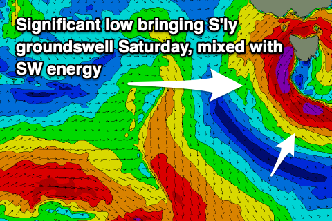
Very dynamic outlook as a strong low deepens across us
Southern Tasmanian Surf Forecast by Craig Brokensha (issued Wednesday September 6th)
Best Days: Friday morning, selected spots Saturday, Sunday morning, Monday, Tuesday morning, Wednesday morning
Features of the Forecast (tl;dr)
- Tiny tomorrow
- Small pulse of SW swell Fri with N tending strong W/SW winds
- Moderate sized S'ly groundswell Sat mixed in with mid-period SW swell along with strong to gale-force W/SW winds, easing
- Easing mix of swells Sun AM with N/NW tending strong SW winds
- Building S/SW groundswell later Sun but more so Mon with N/NW winds
- Easing swell Tue with N tending S winds
Recap
Variable winds created clean conditions yesterday morning along with an inconsistent W/sW groundswell that came in at 1-2ft on the sets. Windy conditions prevailed into the afternoon though as a cold front clipped us, bringing a change late morning.
Today the swell was on the way out, easing from 1-2ft with freshening N/NE tending N/NW winds and improving conditions.

Glassy surf yesterday AM
This week and next (Sep 7 - 15)
Tiny surf is expected into tomorrow, while a weak front moving under us should produce a small pulse to 1-2ft on Friday ahead of some much more significant developments into the weekend.
Winds on Friday will be tricky and likely strong from the N'th, shifting W/SW into the afternoon as a rapidly deepening mid-latitude low develops to our west and starts to edge west.

This low is expected to be quite significant, aiming a fetch of gale to severe-gale S/SW winds, off our West Coast up and into Victoria on Friday, while we're due to see an in-feed of similar strength S/SE winds generated to the south of us, producing a strong S'ly groundswell for Saturday morning.
Unfortunately the low will move east on Saturday, bringing strong to gale-force W/SW winds that will create choppy conditions and also kick up some localised SW swell.
Size wise, 4ft of S'ly groundswell is likely with 3-4ft of mid-period SW energy Saturday, easing rapidly Sunday from 2-3ft as winds swing back offshore from the NW. Due to the dynamic nature of the low allow some room for movement, be that an upgrade/downgrade (check back Friday).
This downwards trend will only be temporary as a strong polar frontal progression pushes up and into us from Sunday afternoon, swinging winds SW and bringing some fresh SW swell energy.
A moderate sized S/SW groundswell is expected from a broad, elongated fetch of strong to gale-force SW winds south of us Sunday and Monday, with the swell building Monday and reaching 4ft through the afternoon, easing from a similar size Tuesday out of the S'th.
Local winds look favourable on Monday and N/NW ahead of a small trough moving in from the west, N'ly Tuesday morning ahead of a shallow S change as the trough moves east.
Expect a bit of movement with the timing of this change and check back Friday.
Small, fun levels of S'ly swell look to persist through the end of the week. More on this Friday.

