Fun weekend of surf
Southern Tasmanian Surf Forecast by Craig Brokensha (issued Friday July 14th)
Best Days: Saturday, Sunday, Monday, Tuesday morning, Wednesday
Features of the Forecast (tl;dr)
- Moderate sized mid-period W/SW swell tomorrow with gusty W/NW winds
- Stronger W/SW groundswell building Sun PM, easing Mon with fresh to strong N/NW winds
- Possible reinforcing W/SW swell Tue with N/NW tending strong S/SW winds, easing Wed with W/NW tending N/NW winds
Recap
A good pulse of S'ly swell provided 2ft+ waves yesterday with great conditions, easing today though replaced with some less consistent, building W/SW swell energy. Conditions are windy and sets are 2ft for the patient.

Good S pulse yesterday
This weekend and next week (Jul 13 - 16)
We've got plenty of W'ly swell on the way as all the frontal activity moving up and across Western Australia is now positioned a little further south and more in our swell window.
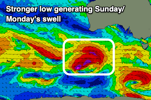
A strong low that's currently pushing in from the west should provide fun 2ft waves through tomorrow, with the possible rare bigger one in the mix while a stronger low pushing in from the west today, will generate a fetch of gale to severe-gale W/NW and W/SW winds, generating a stronger W/SW groundswell for later Sunday afternoon and Monday morning.

With this stronger 3ft sets should be seen across Clifton at its peak.
Local winds will be gusty out of the W/NW tomorrow, with Sunday seeing fresh to strong N/NW winds holding all day, similar Monday.
Into Tuesday we're likely to see a reinforcing pulse of W/SW swell energy from another frontal system moving in towards us Sunday/Monday and this might boost wave heights back to 2ft+.
An onshore S'ly change looks to move in Tuesday afternoon when the swell peaks, improving through Wednesday.
Longer term more W'ly swells are due but in that 2ft range or so. More on this Monday, have a great weekend!

