Tiny until later next week
Southern Tasmanian Surf Forecast by Craig Brokensha (issued Friday April 14th)
Best Days: Thursday next week
Features of the Forecast (tl;dr)
- Tiny, fading E/SE and W/SW swells tomorrow with strong N/NE winds
- Tiny SW swell Mon with N/NW tending variable winds
- Moderate sized W/SW swell building later Wed, peaking Thu, easing into the PM
- W/NW tending fresh W/SW winds Wed, gusty N/NW winds Thu
Recap
Tiny surf yesterday, ideal for beginners, with a small bump of E/SE energy into today though with less favourable winds.
This weekend and next week (Apr 15 - 21)
There's not much to work with this period with the E/SE swell seen today due to fade away along with strong N/NE winds.
The East Coast will offer much better surf so I'd advise checking out Steve's notes which are currently live.

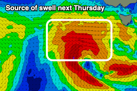
Our next source of noteworthy swell will be from a strong mid-latitude front pushing in under the country early next week, dipping south-east while forming into a low just west-southwest of us on Tuesday evening.
A brief fetch of W/SW gales are expected to be generated through our western swell window, producing a moderate sized W/SW groundswell for Thursday.
We should see a late pulse of swell Wednesday, with Thursday seeing 2ft to occasionally 3ft sets across Clifton along with N/NW winds.
Following this a progression of zonal fronts look to generate small pulses of W/SW swell into the next weekend and beyond, but more on this Monday. Have a great weekend!

