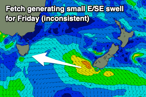
Tiny run of surf, better on the East Coast
Southern Tasmanian Surf Forecast by Craig Brokensha (issued Wednesday April 12th)
Best Days: This afternoon, Friday morning for the keen
Features of the Forecast (tl;dr)
- Tiny E/SE swell tomorrow, with a small pulse for Fri, fading Sat
- Inconsistent, tiny W/SW groundswell Fri, fading Sat
- Light E/NE winds tomorrow, increasing
- Moderate N/NE tending stronger NE winds Fri
- Strong N/NE winds Sat
- S winds Sun
- Tiny W/SW swell Mon with N/NW winds
- Small W/SW swell for Thu next week
Recap
Plenty of swell leftover from the S/SE yesterday but with average winds, cleaner today and back to the 2ft range.

Fun surf this afternoon
This week and weekend (Apr 13 - 16)
The rest of the week looks a bit so/so with the SE swell due to ease, replaced by tiny, inconsistent levels of E/SE swell tomorrow and Friday.
It looks to be 1-1.5ft tomorrow (bigger down the Arm) with 1-2ft sets across Clifton on Friday, thanks to a fetch of strong E/SE winds being generated off the tip of New Zealand's South Island.
There's also expected to be some inconsistent but tiny W/SW groundswell in the mix but only to 1-1.5ft.

Winds are tricky and not ideal for Clifton with E/NE breezes tomorrow, strengthening out of the NE on Friday, but N/NE early in the piece.
Come Saturday the swells will be fading from 1-1.5ft max along with strong N/NE winds, giving into a shallow S'ly change Sunday.
Into next week, a low strengthening but dipping quickly south through our swell window doesn't look overly favourable for swell production, but we may see a small spike of W/SW swell Monday to 1-1.5ft under N/NW winds.
Longer term, most of the week looks tiny, but we'll see some new W/SW swell energy developing later in the week thanks to a flurry of frontal activity up and under Western Australia. This is a little too north to be favourable but the progression is expected to dip south-east, and more into our swell window on Wednesday, generating 2ft or so of W/SW swell for Thursday. We'll take a closer look at this on Friday though.

