Good S/SE swell with improving winds
Southern Tasmanian Surf Forecast by Craig Brokensha (issued Monday April 10th)
Best Days: Tomorrow from later morning, Wednesday morning, early Thursday beginners
Features of the Forecast (tl;dr)
- Moderate sized S/SE swell tomorrow AM, easing and tending SE Wed
- Moderate S/SE winds early, easing and tending light E/SE into the PM
- Light N tending SE winds Wed
- Tiny E/SE swell Thu, with a slightly better pulse Fri
- Variable tending fresh SE winds Thu, moderate E/NE Fri
- Tiny surf Sat/Sun with strong NE winds
Recap
Early light winds on Saturday offered a small window for the keen with a small swell, but the weather and wind moved in through the day, becoming stronger and stormier through yesterday. The swell pushed large into the afternoon with protected spots fairing best, similar today and only for the experienced.
This week and weekend (Apr 11 - 16)
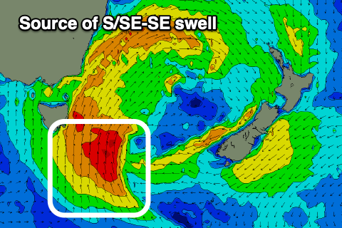
The strong Tasman Low linked to the current run of stormy surf and poor weather was still projecting a fetch of strong to near-gale-force S/SE winds up through our southern and south-eastern swell windows this morning, with it due to weaken considerably overnight tonight.
We'll unfortunately still see lingering S/SE winds tomorrow, moderate early but hopefully going light through the morning and then E/SE into the afternoon.
This should provide improving conditions along with a moderate sized pulse of S/SE swell to 4ft+, (larger down the Arm) easing through the day.
Wednesday will be cleaner and still 2ft to possibly 3ft from the SE along with a N tending SE breeze.

Now, into the end of the week, small levels of E/SE swell are due to persist across the South Arm, especially to the south thanks to the low stalling over near New Zealand, aiming a persistent fetch of strong E/SE-SE winds through our eastern swell window.
Thursday looks smallest and to 1-1.5ft across Clifton, ahead of a small pulse Friday to 1-2ft.
Winds are tricky but likely variable Thursday morning, freshening from the SE, with less than ideal E/NE winds through Friday.
The weekend will see easing levels of E/SE swell with strengthening NE winds as a deepening low in the Bight starts pushing east. At this stage there's no decent swell due from this low or other sources to our west, but more on this Wednesday.

