Cold, large, stormy weekend
Southern Tasmanian Surf Forecast by Craig Brokensha (issued Friday April 7th)
Best Days: Selected spots for the experienced Sunday/Monday, Wednesday
Features of the Forecast (tl;dr)
- Building SW windswell later tomorrow with moderate W/SW winds, strengthening from the SW late AM
- Large, stormy S/SW swell developing Sun, holding Mon from the S, easing later and then down further from the S/SE Tue
- Strong SW tending S/SW winds Sun, strong S/SW winds Mon, fresh S/SW tending weaker S/SE Tue
- Easing SE swell Wed with N tending E/NE winds
- Small E/SE swell for later in the week/weekend
Recap
Plenty of swell with clean conditions and 3ft sets across Clifton yesterday as our SW swell peaked. Today the swell is easing from a more S'ly direction and in the 2ft range on the sets.
This weekend and next week (Apr 8 - 14)
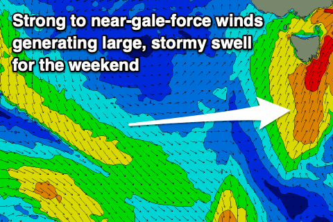
We've got a cold, stormy weekend of surf ahead as a mid-latitude low moving east, across us merges with a polar frontal system pushing up from the south-west.
This will result in the formation of a broad, intense and stalling southern Tasman Low, with persistent, strong southerly winds due to be aimed up and into us from tomorrow through Tuesday, bringing cold weather, snow and large, stormy surf.

Tomorrow looks to be a lay day with a low point in swell and early, moderate W/SW winds ahead of stronger SW winds developing through the day. Some windswell may be seen into the afternoon but Sunday should see a rapid increase in mid-period S/SW swell along with strong SW tending S/SW winds.
The size looks to have been upgraded from Wednesday, with near gale-force winds due to generate stormy 6ft surf across Clifton through the day, if not for the odd bigger one.
The swell should hold a similar size into Monday out of a southerly direction along with strong S/SW winds, with the size starting to ease on Tuesday as the low starts to weaken.
There'll be solid levels of S/SE swell in the water though to 4-5ft, easing through the day and then down from 2ft to maybe 3ft on Wednesday.
Winds will remain average on Tuesday and fresh from the S/SW, tending S/SE and easing through the day, offshore Wednesday and N'ly ahead of E/NE sea breezes.
Longer term the frontal activity up and into Western Australia looks too far north for us but the remnants of the Tasman Low looks to generate small, fun pulses of E/SE swell. More on this Monday. Have a great weekend!

