Fun surf to end the week, poor weekend
Southern Tasmanian Surf Forecast by Craig Brokensha (issued Wednesday April 5th)
Best Days: Tomorrow, Friday morning, selected spots Sunday afternoon and Monday, Wednesday morning
Features of the Forecast (tl;dr)
- Moderate sized SW swell building later today, peaking tomorrow AM, easing into Fri
- Light N/NE tending stronger E/NE winds tomorrow
- Moderate N/NE tending E winds Fri
- Strong SW-S/SW winds developing Sat and Sun with a moderate sized S/SW tending S swell building Sun
- Easing S swell Mon with strong S/SW-S winds
- Moderate sized S/SE swell Tue with lingering S winds, easing Wed with light NW winds
Recap
A drop in swell yesterday though clean and to a fun 1-1.5ft, 1-2ft today with strengthening onshore winds, best at dawn.

Increase in swell this afternoon with strong SW winds
This week and next (Apr 6 - 14)
This afternoon a new pulse of SW swell was expected to start kicking and it looks like Clifton is now a more consistent 2ft but with strong SW winds as the frontal system linked to the swell clips us.
The front linked to this swell initially projected through our south-western swell window, though the backside generated swell more in our southern swell window and we should see a swing in direction through tomorrow afternoon as it eases.
3ft sets are due tomorrow morning across Clifton, with Friday easing back from 2ft max early morning.
Winds will be favourable through the morning and light N/NE ahead of strong E/NE sea breezes, moderate N/NE Friday morning and then E'ly into the afternoon.
A weak mid-latitude low pushing east across us will drag in strengthening S/SW tending SW winds on Saturday as a polar front connects with it, becoming even stronger Sunday out of the S/SW.

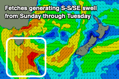
This will kick up a mix of windswell and mid-period S/SW tending S swell energy through Sunday, peaking later, with some reinforcing S/SE energy for Tuesday thanks to a trailing fetch of S/SE winds wrapping around the backside of the low Monday.
Size wise Clifton should build to a stormy 4-5ft on Sunday, easing Monday from the 4ft+ range but still be 4ft Tuesday from the S/SE.
Winds will remain strong from the S/SW-S on Monday with possibly linger S winds on Tuesday. Wednesday looks to be cleaner regardless but with easing levels of S/SE swell from 2ft+.
Longer term a strengthening progression of cold fronts up towards Western Australia from the weekend into next week looks to be too far north of us at this stage, more on this Friday.

