Fun weekend, options continue next week
Southern Tasmanian Surf Forecast by Craig Brokensha (issued Friday March 31st)
Best Days: Protected spots tomorrow, Sunday, Monday morning, Tuesday morning, Thursday morning
Features of the Forecast (tl;dr)
- Peak in W/SW groundswell tomorrow with mod-fresh W/NW tending fresher W/SW winds mid-late PM
- Easing swell Sun with N/NW tending W/NW winds
- Smaller Mon with N/NW tending S/SE winds
- Fading surf Tue with N/NW tending S/SE winds
- Building SW swell Wed with SW winds, peaking Thu with N/NE tending SE winds
Recap
Tiny waves yesterday while today we've seen a localised windswell mixed in with a building W/SW groundswell that's now 2-3ft and choppy.

Choppy surf but with a bit of size this afternoon
This weekend and next week (Apr 1 - 7)
Looking at the weekend ahead, and this afternoon's increase in W/SW groundswell is due to peak tomorrow with surf to 3ft across Clifton with windy but cleaner conditions.
A moderate to fresh W/NW breeze is due through the morning, increasing while tending W/SW mid-late afternoon.
Sunday will be cleaner and still a good size with easing 2ft to occasionally 3ft sets under a N/NW tending W/NW breeze.
Smaller surf is expected into next week but still to 2ft on Monday, dropping to 1-2ft on Tuesday and with morning offshores ahead of S/SE sea breezes.

Longer term we've got some convergence with the model outputs, and it's workable for our region.
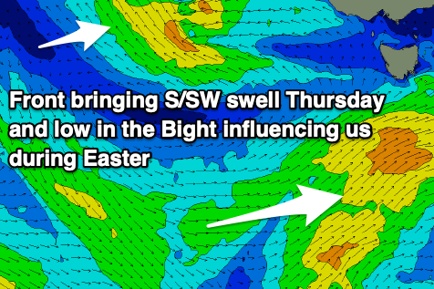
A small mid-period pulse of SW tending S/SW swell is due for Wednesday/Thursday with initial onshore winds that'll improve.
This swell will be generated by a weak polar front pushing up and under us Tuesday/Wednesday, with an onshore change arriving with the building swell Wednesday ahead of a peak Thursday to 2ft to possibly 3ft along with hopefully morning offshores. Following this a broad mid-latitude low forming in the Bight will move slowly east, resulting in no swell for us until it moves into the Tasman Sea Easter, possibly bringing some stormy SE windswell. More on this Monday, have a great weekend!

