Strong swell for the weekend with workable winds
Southern Tasmanian Surf Forecast by Craig Brokensha (issued Wednesday March 29th)
Best Days: Today, Saturday morning, Sunday morning, Monday morning
Features of the Forecast (tl;dr)
- Poor mix of SW windswell and S/SE groundswell tomorrow, easing Fri
- Strong S/SW winds tomorrow, gusty W/SW tending SW Fri
- Moderate sized W/SW groundswell building Fri PM, peaking Sat AM with fresh W/NW tending W/SW-SW winds
- Slowly easing swell Sun with NW tending W/SW-SW winds
- Fading swell Mon and Tue
Recap
Poor winds and surf yesterday with easing 2ft sets, cleaner today and still 1-2ft across Clifton.

Cleaner surf early this arv
This week and weekend (Mar 30 – Apr 2)
Tomorrow will be poor across the state as deepening surface trough brings strong S/SW winds and a mix of small windswell and background S/SE groundswell.
Friday doesn't look much better with a slight shift in winds to the W/SW, remaining gusty before slipping SW late morning.

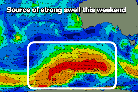
Swell wise, a strong new W/SW groundswell is due to arrive into Friday afternoon and peak Saturday, generated by a healthy polar frontal progression that's sitting south of the country and west-southwest of us.
A broad and elongated fetch of gale to severe-gale W/SW winds have been generated with a weaker trailing fetch of W/SW gales now being aimed through our swell window.
The swell event will be prolonged, arriving Friday afternoon but peaking Saturday morning to 3ft on the sets, with Sunday easing from 2-3ft.
Winds should improve Saturday and shift W/NW through the morning, W/SW-SW through the afternoon while Sunday should offer NW tending W/SW-SW winds
Smaller surf with cleaner conditions is due on Monday morning while a deepening trough to our east will bring unfavourable E-SE winds on Tuesday/Wednesday. Beyond this the outlook is too tricky to call thanks to model divergence but check back here Friday for the latest.

