Tricky winds this week, good swell for the weekend
Southern Tasmanian Surf Forecast by Craig Brokensha (issued Monday March 27th)
Best Days: Selected spots tomorrow, Wednesday morning, Sunday morning
Features of the Forecast (tl;dr)
- Easing SW swell tomorrow with strong E/NE winds, tiny Wed with W/NW-NW tending S/SW winds mid-late PM
- Moderate sized W/SW groundswell building later Fri with NW tending S/SW winds, peaking Sat with gusty SW winds
- Easing surf Sun with W/NW tending SW winds
Recap
Plenty of swell for the weekend and with favourable winds, strongest yesterday with solid waves at the deep water reefs.
Today is smaller and onshore following a weak trough.
This week and weekend (Mar 28 – Apr 2)
The current swell will continue to ease over the coming days, but tomorrow should still be 2ft on the sets, fading from 1-1.5ft Wednesday and bottoming out into Thursday.
A deepening surface trough across the state will bring poor, strong E/NE winds tomorrow, shifting W/NW-N/NW on Wednesday before a trough brings a S/SW change mid-late afternoon.
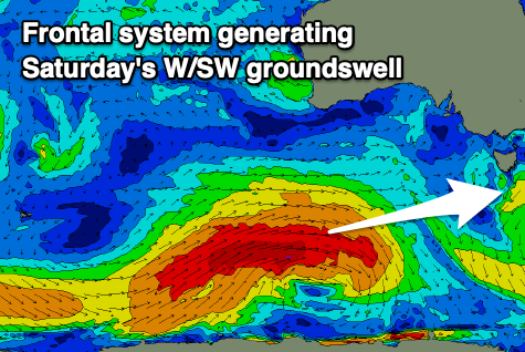
W/SW winds will persist Thursday morning as the swell bottoms out, but into Friday we should see some good new W/SW groundswell building, peaking through Saturday.

The source of this swell will be a strong polar frontal progression forming to the south-southwest of Western Australia tomorrow, generating a fetch of gale to severe-gale W'ly winds through our swell window until Wednesday morning, then weakening but still maintaining strong W/SW winds in our swell window until Friday.
This will prolong the swell event with a good kick in size due later Friday to 2ft, but with a mid-late afternoon SW change, peaking Saturday to 3ft but with strong SW winds.
Sunday morning should hopefully be cleaner as wind tip W/NW and the surf easing slowly from 2ft to possibly 3ft.
Moving into next week the outlook is slow with small to tiny background swells expected with light morning winds, but we'll review this Wednesday.


Comments
Hey Craig, what’s your thoughts on the swell production from the low that’s currently s/sw of NZ. Looking at mslp charts on BOM shows a strong fetch of SSE projecting towards Tas. Is it too far away that the swell would be ironed out by winds or not aligned correctly? I’m assuming the ice shelf also comes into play depending on time of year too?
It's in a good position for S/SE swell generation, but a little too disorganised and not that strong to generate anything really over 1-2ft IMHO Thursday.