Pick your poison this week
Southern Tasmanian Surf Forecast by Craig Brokensha (issued Monday March 13th)
Best Days: Tomorrow morning, mid-late morning Wednesday and into the afternoon ahead of sea breezes, early Thursday, Friday, Saturday morning, Sunday morning, Monday morning
Features of the Forecast (tl;dr)
- Easing surf tomorrow with N tending S/SE winds
- Building W/SW groundswell Wed PM, holding Thu AM
- N tending S/SE winds mid-PM Wed, gusty N/NW early Thu ahead of a W/SW change mid-late AM
- Reinforcing W/SW swell for Thu PM and Fri, easing Sat
- W/NW winds Fri
- N tending strong E/NE winds Sat
- Moderate sized mid-period W/SW swell for Sun/Mon with morning offshores
Recap
Clean conditions with fun sets holding 2ft through the weekend, building through yesterday but with a change pushing through late morning.
Today the swell is still with us and coming in at 3ft+ across Clifton with early favourable winds. Sea breezes are adding bumps and chops to the swell.
This week and weekend (Mar 14 – 19)
The coming week will remain active with incoming swells and favourable winds, though we'll see the surf drop through tomorrow first.
Clifton should still be 1-2ft and conditions look clean with a morning N'ly offshore before E/SE sea breezes kick in.

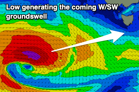
Wednesday morning will initially start slow, but some new W/SW groundswell is due to arrive mid-late morning, pulsing nicely into the afternoon.
The source of this swell is a strengthening low to the south of Western Australia, with a fetch of gale to severe-gale W/NW winds tracking east-southeast through our western swell window.
The low isn't ideally positioned but the strength should overcome this, with building sets to 2-3ft due into Wednesday afternoon before easing from a similar size Thursday.
Conditions will be clean Wednesday morning ahead of mid-afternoon sea breezes, best at dawn Thursday with a gusty N/NW offshore ahead of a W/SW change mid-late morning.
This strong change will be linked to a strengthening frontal system pushing across us, producing some reinforcing mid-period energy to 2ft through Thursday afternoon and Friday.

The models are over-forecasting this energy and adding the mid-period swell to the easing groundswell, but either way fun waves will continue with W/NW winds Friday and N'ly tending E/NE winds Saturday as it eases.
Behind Thursday's front, drawn out frontal activity extending nearly to the Heard Island region will produce some fun mid-period W/SW swell energy from Sunday through Monday to 2ft, with further swells due into next week.
Conditions will remain favourable with morning offshore winds out of the north-western quadrant, but we'll confirm this Wednesday.

