Fun surf from Wednesday
Southern Tasmanian Surf Forecast by Craig Brokensha (issued Monday March 6th)
Best Days: Wednesday, Thursday, Friday, Saturday, dawn Sunday
Features of the Forecast (tl;dr)
- Easing surf tomorrow with gusty N/NW-NW winds
- Building W/SW swell Wed with strong NW tending W/NW winds
- Easing swell Thu with N/NW tending W winds
- Reinforcing S/SW swell Thu PM, easing Fri with N/NW tending variable winds
- Building swell Sat with N/NW tending variable winds, easing Sun with variable tending strong S/SW winds.
Recap
Great conditions on Saturday with plenty of swell still to 2-3ft, good again yesterday but easing from 1-2ft.
Today a small pulse of SW groundswell has maintained 1-2ft sets across Clifton.
This week and weekend (Mar 7 – 12)
Tomorrow will be small with the current groundswell expected to ease, while the swell comes in too west to get into Clifton. It might be 1-1.5ft early along with gusty N/NW-NW winds.
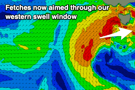
Looking at the rest of the week, and the slow moving Southern Ocean gyre now looks to stall a little too far west than ideal for us.
All the frontal activity will be aimed up and into South Australia and Victoria, with us only now expected to see some smaller, W/SW swell energy spreading out radially from fetches of strong to gale-force winds.
This is unfortunate but we should still see 2-3ft sets through Wednesday afternoon, easing from a similar size Thursday morning.

A final pulse of reinforcing S/SW swell is due Thursday afternoon, generated by the most favourably aligned but weakest front south of us Wednesday evening, and this should slow the easing trend, with Friday due to ease from 2ft.
Locally winds will be strong from the NW tending W/NW on Wednesday, with N/NW tending W winds Thursday.
Friday looks clean again with a N/NW offshore, tending variable ahead of possible weak sea breezes, then N/NW tending variable on Saturday again.
On Saturday afternoon a small pulse of reinforcing mid-period SW swell is due, generated by a weak but healthy polar front moving under us Friday and this should boost sets to 2ft through the afternoon, easing Sunday.
We might see early W/NW winds Sunday but a trough will bring a strong S/SW change mid-morning. We'll confirm this Wednesday.
Longer term the outlook goes quiet so make the most of the coming surf.


Comments
And ain’t that a fall from grace. The dreaded Tassie downgrade.
Craig, is there any other surf region that receives greater size downgrades than southern Tassie?
I'd say West Coast New Zealand would, as any change to the storm track would make or break a swell getting in, just like Tassie.