Active period with generally favourable winds
Southern Tasmanian Surf Forecast by Craig Brokensha (issued Wednesday March 1st)
Best Days: Tomorrow morning, middle of the day Friday, Saturday and Sunday mornings, Monday morning
Features of the Forecast (tl;dr)
- New mid-period SW swell Thu with W/NW winds, shifting SW late AM, stronger S/SW late PM
- Stronger W/SW swell building Thu PM, holding Fri AM
- Stronger SW groundswell for later Fri, easing Sat
- Fresh SW winds Fri AM, easing and tending variable ahead of sea breezes
- Light N/NE tending strong E/NE Sat, strong N/NE tending E/NE Sun
- Small W/SW groundswell Mon with strong N/NE tending weaker N/NW winds
- Good W/SW swells later next week
Recap
Plenty of swell with clean conditions and 2-3ft sets yesterday, easing through the day and back to 1-1.5ft this morning.
This week and next (Mar 2 - 10)
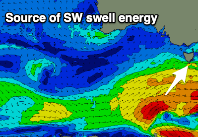
From tomorrow we've got a good run of swell, firstly arriving from the SW ahead of some new W/SW swell energy into the afternoon, peaking Friday.

This activity has and is still being generated by a progression of healthy fronts through our swell windows the last few days.
An initial weak low should produce 2ft waves tomorrow morning, but a broader and stronger system that's currently pushing in from the south-west should generate better 2-3ft surf tomorrow afternoon and Friday morning.
One final push of SW gales through our south-western swell window tomorrow should generate a stronger pulse to a more consistent 3ft later Friday, easing from 3ft on Saturday morning.
Looking at the local winds and a morning W/NW breeze is due tomorrow, shifting SW late morning/midday and then stronger S/SW into the late afternoon.

Friday is still looking dicey, with gusty dawn SW winds due to ease and tend variable late morning before sea breezes kick in. There should be a window through the middle of the day for lumpy, workable surf.
Saturday looks great with a light N/NE offshore ahead of stronger E/NE sea breezes, smaller Sunday with strong N/NE tending E/NE winds.
Moving into Monday a new pulse of inconsistent W/SW groundswell should build, but following this, a slow moving gyre of polar fronts and lows will move in, stalling across us mid-week.
This will bring windy, building swell out of the W/SW later week but we'll have a closer look at this Friday.

