Plenty of swell with lots of windows for a clean runner
Southern Tasmanian Surf Forecast by Craig Brokensha (issued Monday February 27th)
Best Days: Tomorrow ahead of the change, dawn Wednesday, Thursday morning, Friday later morning, Saturday morning, Sunday
Features of the Forecast (tl;dr)
- Moderate sized W/SW groundswell easing slowly tomorrow with variable N winds ahead of a S/SE change mid-PM
- Fading surf Wed with dawn W/NW winds, shifting SW'ly shortly after
- New mid-period SW swell Thu with N/NW winds ahead of S/SE sea breezes
- Stronger W/SW swell Fri, peaking in the PM out of the SW, easing Sat
- Mod-fresh SW winds Fri AM, easing and tending variable ahead of sea breezes
- Light N/NE tending strong E/NE Sat, strong N/NE Sun
Recap
Friday's pulse of S/SE swell held in at 1-1.5ft Saturday morning with a strengthening N/NE breeze, tiny yesterday but OK for beginners.
Today we've got our W/SW groundswell in the water with light winds this morning and 2-3ft sets, now choppy with a strengthening S'ly wind.
This week and weekend (Feb 28 – Mar 5)
Tomorrow morning should be much cleaner across the South Arm as a variable, N'ly breeze develops, remaining light until mid-afternoon ahead of a trough and gusty S/SE breeze around 2pm.
Size wise, a reinforcing pulse of W/SW groundswell should hold wave heights around 2ft, if not for the odd 3ft'er in the morning, easing slowly with smaller 1-2ft sets on Wednesday morning. A dawn W/NW breeze will create clean conditions Wednesday, though quickly shift gusty SW through the morning.
Moving into the end of the week, we've got plenty of swell due, but again troughy weather will bring dicey winds.

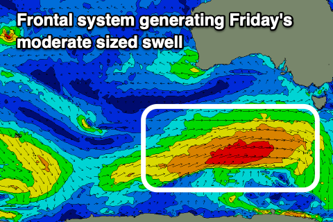
On Thursday a new pulse of mid-period SW swell is due, generated by a weak fetch of W'ly winds currently south of Western Australia. Good 2ft sets are due along with N/NW winds ahead of S/SE sea breezes.
A stronger pulse of mid-period W/SW swell is due into the afternoon and Friday, generated by a secondary front firing up on the tail of the initial weak fetch.
A broader fetch of sub-gale-force W/SW winds should produce 2-3ft of swell for Thursday afternoon and Friday, while a small intensification of SW gales south of us on Thursday looks to push wave heights more to 3ft into Friday afternoon and Saturday morning.
The stalling nature of the progression will unfortunately bring with it moderate to fresh but easing SW winds on Friday, N/NE tending stronger E/NE winds on Saturday. The rest of the weekend looks mostly clean but with small, fading sets so make the most of the windows Friday and Saturday.
Longer term there's plenty more frontal activity on the cards for next week and beyond but check back here Wednesday for more details.

