Fun swells early next week but with tricky winds
Southern Tasmanian Surf Forecast by Craig Brokensha (issued Friday February 24th)
Best Days: Beginners tomorrow morning, Tuesday ahead of sea breezes, Thursday morning
Features of the Forecast (tl;dr)
- Tiny, easing S/SE groundswell tomorrow with fresh N/NE winds, tending strong S/SE-SE and the S from midday
- Moderate sized W/SW groundswell building Sun PM, peaking Mon, with a reinforcing pulse for Tue AM, easing
- Strong S/SE tending S winds Sun, SW tending S Mon
- Light-mod N/NE winds Tue, ahead of late sea breezes
- Strong SW winds Wed
Recap
Tiny fading surf yesterday, ideal for beginners, near flat this morning. Our new pulse of inconsistent S/SE groundswell is now showing with bumpy 1-1.5ft sets across the beaches.

New SSE swell lines this arvo
This weekend and next week (Feb 25 – Mar 3)
This afternoon's slow pulse of S/SE groundswell should ease tomorrow morning from a smaller 1-1.5ft under gusty N/NE winds, shifting S/SE-SE around midday and then strong S into the afternoon.
This change will be linked to a trough moving across us, forming into a low Sunday, bringing poor S/SE tending strong S winds along with a building S'ly windswell.
No major size is expected and unfortunately it looks like gusty SW winds will persist into Monday, shifting S into the afternoon ahead of cleaner conditions on Tuesday.

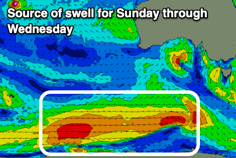
This will be when some better, inconsistent W/SW groundswell fills in, generated by a healthy and elongated polar frontal system pushing east along the shelf. The progression formed yesterday around the Heard Island region, with gale to severe-gale W/SW winds produced in our far swell window, with it weakening south of Western Australia today. This should produce an inconsistent groundswell for later Sunday but more so Monday to 3ft on the sets.
A trailing fetch of strong to gale-force W/SW winds is expected to produce a reinforcing swell for Tuesday morning slowing the easing trend with 2ft to occasionally 3ft sets due, easing further from 1-2ft on Wednesday.
As touched on earlier a light to moderate N/NE'ly is due Tuesday ahead of sea breezes, while a trough will bring a SW change on Wednesday, cleaner Thursday.
Longer term we'll see a succession of polar storms pushing up and across us next weekend and into the following week, bringing plenty of swell, but more on this Monday. Have a great weekend!

