Good surf Sunday, strong and powerful early week
Southern Tasmanian Surf Forecast by Craig Brokensha (issued Friday February 17th)
Best Days: Sunday ahead of the afternoon change, dawn Monday, Wednesday morning
Features of the Forecast (tl;dr)
- Good W/SW swell Sun with moderate N/NW tending variable, then S/SW winds mid-late PM
- Moderate sized + W/SW groundswell building strongly Mon, easing Tue
- Early NW tending gusty S/SW winds Mon, S/SE into the PM
- Strong SW winds Tue
- Easing surf Wed with N tending SE winds
Recap
Good clean conditions with some inconsistent W/SW groundswell to 1-2ft yesterday, easing back to a tiny 1ft today.

Cracker day on the Arm
This weekend and next week (Feb 18 - 24)
The swell is due to reach a low point tomorrow morning with light, morning offshore winds ahead of a trough and afternoon S/SW change.
Moving into Sunday, a good pulse of mid-period W/SW swell is due to arrive thanks to a strengthening mid-latitude front dropping south-east through our swell window today. This should provide fun 2ft+ sets across Clifton on Sunday with 3ft sets likely under a N/NW offshore that should only tend variable early afternoon ahead of a S/SE sea breeze and late S/SW change.
Monday is an interesting day as we'll see a window of morning, N/NW offshore winds before a trough brings a S/SW change late morning that will likely see sea breezes override it and bring S/SE winds into the mid-late afternoon.

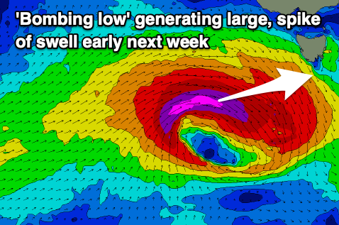
Swell wise, the large W/SW groundswell mentioned in Wednesday's update is on track, with explosive cyclogenesis forecast to occur south of the country tomorrow. That being a low moving in from the west undergoing a rapid drop in central pressure, exceeding the required 24hPa within 24 hours to meet the 'bombing low' classification.
This will result in a rapid escalation of wind speeds with pre-frontal W/NW gales due to be followed by severe-gale to storm-force W'ly winds. This all sounds great but there's one slight issue, the fast track of the low to the east and local winds when it peaks.
The swell will build rapidly but be short-lived thanks to the fast track of the low, with it building from first light Monday, peaking into the afternoon.
Clifton should see surf pulsing to 4-5ft but with a dawn N/NW offshore quickly shifting S/SW, then S/SE into the afternoon. Not ideal. Tuesday will then see stronger SW winds, with the swell easing rapidly from 3-4ft range.
Wednesday will become cleaner but the surf back to a smaller 2ft+.
Longer term there's nothing too significant on the cards to check back here on Monday for the latest. Have a great weekend!

