Tiny end to the week, increasing swell from the weekend
Southern Tasmanian Surf Forecast by Craig Brokensha (issued Wednesday February 15th)
Best Days: Beginners tomorrow and Friday morning, Sunday, Wednesday morning selected spots
Features of the Forecast (tl;dr)
- Tiny W/SW swells tomorrow and Fri, easing Sat
- N tending SE winds tomorrow, N/NE tending gusty E/NE Fri ahead of a late PM S/SW wind shift
- W/NW tending S/SW winds Sat
- Good W/SW swell Sun with gusty N/NW tending W/NW winds
- Moderate sized W/SW groundswell building strongly later Mon, easing Tue
- Moderate W/SW tending stronger S/SW winds Mon, SW tending S/SW Tue
- Easing surf Wed with strengthening E/NE winds
Recap
Tiny, clean surf for beginners both yesterday and this morning.
This week and next (Feb 16 - 24)
Tiny surf to 1-1.5ft is expected to continue through tomorrow and Friday thanks to persistent, northerly positioned and relatively weak frontal activity occurring south of Western Australia and the Bight.
Conditions will be clean each morning with a N'ly offshore, giving into weak sea breezes tomorrow, stronger on Friday ahead of a late afternoon, shallow S/SW change.
It looks like we'll reach a temporary low point in swell Saturday morning ahead of an upgraded increase in W/SW energy on Sunday.
This will be produced by a strengthening mid-latitude front dipping east-southeast while moving towards us on Friday. A strengthening fetch of strong to gale-force W'ly winds should generate some fun size Sunday, coming in at 2ft+ across Clifton.
Winds look great on Sunday and fresh out of the N/NW, shifting W/NW later as a strong low starts moving in from the west.

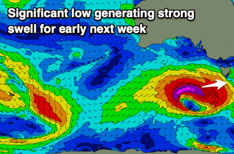
Now, this low is due to be quiet significant with it deepening rapidly under Western Australia on Saturday evening and through Sunday.
A fetch of severe-gale to possibly storm-force W'ly winds will be generated in our western swell window, generating a moderate sized W/SW groundswell for later Monday and Tuesday morning.
Size wise it looks to build to 4ft by dark Monday but with SW tending S winds, easing from a similar size Tuesday as winds unfortunately hold onshore out of the W/SW tending S/SW.
This will create average conditions throughout the whole swell, cleaner Wednesday as it eases with E/NE winds (not ideal). Check back here on Friday for confirmation on this local winds with the swell event.

