New swell for tomorrow as winds deteriorate
Southern Tasmanian Surf Forecast by Craig Brokensha (issued Monday February 6th)
Best Days: Now, early tomorrow, Wednesday for the keen, Thursday morning
Features of the Forecast (tl;dr)
- Moderate sized mid-period SW swell building tomorrow with early W/NW winds, shifting SW mid-AM and then strong S into the PM
- Easing S/SW swell Wed with light-mod S/SW-SW tending S/SE winds
- Fading surf Thu with N tending S/SE winds
- Tiny Fri
- Small new S/SW swell Sat with S winds
Recap
Clean conditions and a drop in swell back from Friday to 2ft, while a new pulse of S'ly swell was seen through the day as onshore winds kicked in.
Sunday saw a sloppy mix of swells to 2ft with cross-shore winds for the keen beans. An inconsistent SW groundswell due into yesterday afternoon has eased back to a slower 2ft this morning under all day offshore winds.

Winds are still offshore!
This week and weekend (Feb 7 - 12)
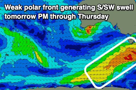
Today's strengthening offshore winds are linked to an approaching polar frontal system, with a weak but elongated fetch of strong SW winds being projected up and through our south-western swell window.
This will produce some new mid-period SW swell for tomorrow (as the SW groundswell fades), coming in at 2ft to occasionally 3ft through tomorrow afternoon, easing from a similar size on Wednesday morning.

Winds will be W/NW at dawn tomorrow but shift fresh SW mid-morning and then S'ly into the afternoon while strengthening. Therefore go the early. Winds will linger out of the S/SW-SW on Wednesday with the easing swell, not ideal but still surfable, with Thursday coming in cleaner with a N'ly breeze and easing 1-2ft sets.
Moving into the weekend, a small, weak front firing up late in our swell window may generate a small 1-2ft of S/SW swell for Saturday morning but with dicey S/SW winds. Following this, weaker fronts moving through our swell window should generate small pulses of swell next week along with favourable winds. More on this Wednesday.

