Tricky mix of swells with variable winds
Southern Tasmanian Surf Forecast by Craig Brokensha (issued Friday February 3rd)
Best Days: Tomorrow (protected spots PM), Monday morning, early Tuesday
Features of the Forecast (tl;dr)
- Easing W/SW swell Sat with a new S swell for the PM and fresh N/NW winds ahead of a W/SW-SW PM change, possibly holding W until near dark
- Small mix of swells Sun AM with strong W/SW winds, tending SW and then S/SE
- Inconsistent but strong SW groundswell building Sun PM, easing Mon with N/NW tending W/SW winds
- Building mid-period SW swell Tue with W/NW tending SW winds mid AM, with easing surf Wed with SW winds
Recap
Fun clean options yesterday coming in at 2ft, while today our stronger W/SW groundswell was offering straight but clean 2-3ft waves this morning. Winds have since gone onshore.

Clean conditions this AM
This weekend and next week (Feb 4 - 10)
Currently a cold low is sitting to our west and will sit there through this evening before stating to move east through tomorrow.
With this we'll see strengthen from the N/NW overnight, easing at dawn and through tomorrow morning, shifting W/NW later morning ahead of a W/SW-SW change around midday/early afternoon. There's a chance winds hold from the W into the afternoon as the low axis moves across us, with a stronger SW change on dark.

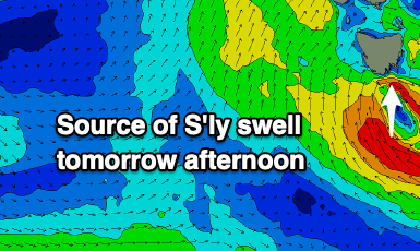
Swell wise, today's energy is due to ease from 2ft+, but some new S'ly swell is due to arrive through the morning, generated by a very short-lived fetch of strong to gale-force S/SE winds in our southern swell window this afternoon.
This should kick to 2-3ft into the afternoon, with fading surf Sunday from 1-2ft.
Unfortunately winds look to be strong out of the W/SW on Sunday morning as we fall under the influence of the backside of the low. Winds look to shift SW and then S/SE later afternoon, spoiling a new pulse of long-period SW groundswell.
This swell which was discussed this week should build to 3ft into Sunday afternoon before easing from an inconsistent 2-3ft on Monday morning along with a great N/NW offshore that will shift W/SW later morning.
Moving into Tuesday and a broad but relatively weak polar front moving through our south-western swell window on Monday, bringing the W/SW change will generate some new mid-period SW swell for Tuesday, building to 2ft+, easing from a similar size on Wednesday.
There'll be a small window of W/NW winds early Tuesday before shifting SW, and then poor out of the S, with Wednesday looking dicey with lingering SW winds. We'll have a closer look at this Monday.
Longer term the outlook is slower so make the most of the current swell. Have a great weekend!

