Very active period ahead
Southern Tasmanian Surf Forecast by Craig Brokensha (issued Friday January 27th)
Best Days: Tomorrow morning, Wednesday morning, Thursday, Friday morning, Saturday morning
Features of the Forecast (tl;dr)
- Moderate sized W/SW swell building today, holding tomorrow with a reinforcing pulse for Wed/Thu
- Variable winds tomorrow AM ahead of SE sea breezes
- NW tending strong S/SW winds mid-late AM Wed
- N-N/NW winds Thu
- Moderate sized W/SW groundswell building Fri with early NW winds, tending S/SW mid-late AM
- Easing surf Sat with N/NW winds ahead of a mid-late AM SW change
- Moderate sized SW groundswell Sun with gusty SW winds, possibly W early
Recap
Slow but clean conditions Saturday morning with easing 1-2ft sets, tiny and bumpy into yesterday as a trough moved through.
Today we've got our good building W/SW swell energy with slow 1-2ft sets this morning, a bit bigger this afternoon but torn to shreds by sea breezes.
This weekend and next week (Jan 28 – Feb 3)
We've got a ton of west swell due this week across the state, owing to an over-active westerly storm track. Today's increase was generated by a strong polar low come frontal system pushing east late last week and through the weekend.

We should see the swell holding mostly 2ft tomorrow with the rare 3ft'er for the patient and with favourable, variable winds ahead of sea breezes.
Following this initial storm we're seeing an elongated fetch of strong to sub-gale-force W-W/SW winds being drawn out under the country and this will produce lots of reinforcing energy holding 2ft+ through Wednesday and Thursday.
Conditions will be great Wednesday morning with a NW offshore but a trough will bring a S/SW change mid-late morning, with Thursday seeing all day offshore N/NW-N winds thanks to a strong, approaching polar low.
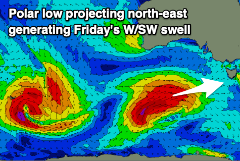
Now, this low will form on the back of the elongated frontal progression, with a fetch of gale to severe-gale W/SW winds expected to generated through our western swell window before the low pushes north-east, up and into Victoria.
The low will actually stall late week, resulting in winds being favourable through Friday morning as the swell arrives, but this isn't ideal regarding the final direction of the incoming swell.
It'll be west in nature but should come in at 2-3ft when it peaks later morning Friday with a light N/NW breeze ahead of a shallow S/SW change mid-late morning. Getting the swell before the change moves in might be a bit tricky.

Saturday morning will see the swell ease from 2ft but with favourable N/NW winds ahead of another change mid-late morning.
A better angled SW groundswell looks to be inbound Sunday, produced by an extra-tropical low dipping south-east into the westerly storm track, to the south-west of Western Australia. This will cause the low to intensify with a fetch of severe-gale to storm-force W/NW winds due to be generated through our south-western swell window.
A stronger, long-period SW groundswell is on the cards for Sunday afternoon, coming in at 3ft+ but with lingering SW winds after Saturday's change. We'll confirm this on Wednesday though.

