Slow weekend, lots of swell next week
Southern Tasmanian Surf Forecast by Craig Brokensha (issued Friday January 27th)
Best Days: Tomorrow morning selected spots, Monday morning, Tuesday morning, early Wednesday, Thursday morning
Features of the Forecast (tl;dr)
- Fading mix of W/SW and SE swells tomorrow with fresh to strong N/NE winds, easing ahead of a late SW change
- Tiny Sun with mod-fresh SW tending S/SE winds
- Moderate sized W/SW swell building Mon, holding Tue with a reinforcing pulse for Wed, easing Thu
- N tending E/NE then SE winds Mon
- Light S/SE winds, strengthening Tue
- NW tending strong SW winds mid-late AM Wed
- N tending SW winds Thu
Recap
Fun waves yesterday with small 1-2ft sets, best in protected spots with west winds ahead of a change. This morning there was a bit more energy and clean conditions but sea breezes are now in.
This weekend and next week (Jan 28 – Feb 3)
Looking at the weekend ahead and today's swell is due to fade tomorrow with 1-1.5ft sets across Clifton with strong but easing N/NE winds, favouring some spots over others. Winds are due to abate into the afternoon with an approaching trough with a SW change on dark.
Sunday will become tiny and winds look to linger out of the SW creating average conditions, shifting S/SE into the afternoon and freshening.
Looking at next week and there's a ton of swell energy inbound, mostly coming in out of the west thanks to a flurry of polar frontal activity.
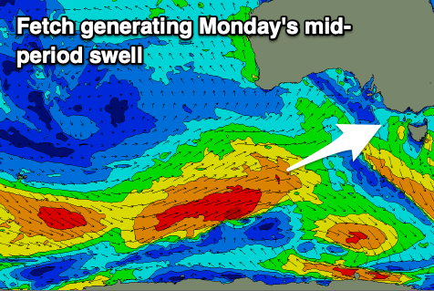
An initial polar low that formed around the Heard Island region is now pushing east while generating a great fetch of strong to gale-force W/SW winds.
This should generate a moderate sized mid-period W/SW swell for Monday, building to a peak into the afternoon with 2ft to occasionally 3ft sets due across Clifton.

Similar sized waves are due on Tuesday, with a slight drop in size to a less consistent 2ft due on Wednesday.
Following frontal activity will see gale-force W/NW winds generating some reinforcing W/SW groundswell for Wednesday, taking over the easing swell from Tuesday with sets to 2-3ft, slowly easing Thursday.
Following this, one more strengthening polar outbreak on the back of the progression may generate a sizier swell for late week but we'll look at this again on Monday.
Locally winds will be offshore Monday morning out of the N ahead of sea breezes, with light, variable S'ly winds due into Tuesday morning following a trough. Wednesday should be clean again with a NW offshore ahead of a mid-late morning SW change, clean again Thursday.
With the uncertainty of the strengthening system late week we'll have to review the outlook on Monday. Have a great weekend!

