Small swells ruined by local winds
Southern Tasmanian Surf Forecast by Craig Brokensha (issued Friday December 30th)
Best Days: Selected spots Sunday morning and Monday morning ahead of the change
Features of the Forecast (tl;dr)
- Small, inconsistent W/SW groundswell for later Sat with NE tending strong E/NE winds, easing Sun with gusty N/NE tending strong E/NE winds
- Inconsistent W/SW swell building Mon with N/NE tending E/NE winds ahead of a mid-afternoon S/SW change
- Steady W/SW swell Tue with W/SW tending S/SW winds
- Smaller Wed with lingering S/SW winds, freshening
Recap
Small increase in localised swell yesterday to 1-2ft, fading today and back to 1ft, ideal for beginners.
This weekend and next weekend (Dec 31 – Jan 6)
Tomorrow will be tiny again, though an inconsistent W/SW groundswell is due into the afternoon to 1-2ft, easing Sunday from a similar size. The source was a distant fetch of short-lived W/SW gales on Monday, south-southwest of Western Australia.

Conditions won't be great with a morning NE breeze tomorrow due to strengthen from the E/NE through the day, remaining gusty from the N/NE on Sunday morning and strong into the afternoon out of the E/NE again.
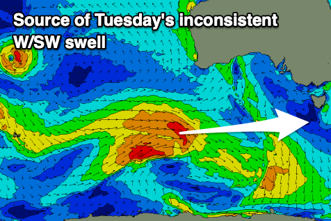
Into early-mid next week we've got some fun though inconsistent levels of mid-period W/SW swell due across Clifton.
These have and are still being generated by a broad, healthy polar frontal progression that formed around the Heard Island region in our far swell window.
The first swell for Monday, building to a peak through the afternoon was generated by the strongest fetch, with a secondary pulse due Tuesday from a secondary intensification firing up to the south of Western Australia tomorrow.
The first looks to build to a slow 2ft through the afternoon, with the secondary swell holding this size Tuesday.

Following this activity, some weaker fronts may maintain 1-2ft surf through Wednesday and Thursday but we'll have another look at this Monday.
Locally, winds don't look ideal with Monday morning being clean with a N/NE offshore, shifting E/NE early afternoon ahead of a trough and S/SW change mid-late afternoon.
It looks like winds may linger out of the W/SW Tuesday morning, shifting S/SW through the day and strengthening with lingering S/SW winds Wednesday. Check back Monday for confirmation on this though.
Have a great weekend and Happy New Year!

