Slow period after today's swell drops
Southern Tasmanian Surf Forecast by Craig Brokensha (issued Monday December 26th)
Best Days: Tomorrow morning, beginners Wednesday morning, Thursday morning for the keen, Saturday morning for the keen
Features of the Forecast (tl;dr)
- Easing SW groundswell tomorrow with N/NE tending strong E/NE winds
- Tiny Wed with strong N winds, tending W ahead of a stronger afternoon change from the W/SW-SW
- Weak W/SW windswell Thu AM, easing with W/NW tending E/NE winds
- Small inconsistent W/SW groundswell for Sat PM, easing Sun
- N/NE tending E/NE winds Sat, with N tending S winds Sun
Recap
Tiny surf Saturday with light winds, kicking through yesterday with a good pulse of new W/SW swell with 2ft sets and morning offshore winds.
This morning the swell was holding 2ft but with a weak onshore breeze, and into this afternoon out strong W/SW groundswell has filled in with 3ft sets but a fresh sea breeze.

Solid buy onshore sets this afternoon
This week and weekend (Dec 27 – Jan 1)
This afternoon's strong and straight W/SW groundswell will peak this evening and drop steadily through tomorrow thanks to the 'bombing' low linked to it pushing fairly quickly through our swell window.
This will see easing 2-3ft sets across Clifton tomorrow morning but with offshore N/NE winds, strengthening from the E/NE into the afternoon.
Wednesday will be small and back to 1-1.5ft but with early strong N winds ahead of a weaker W change late morning, then stronger W/SW-SW winds into the afternoon.
This change will be linked to a weakening mid-latitude front pushing across us, bringing a small, weak pulse of W/SW windswell for Thursday morning. It looks to be 1-2ft max and easing through the day but with a light W/NW morning breeze ahead of E/NE sea breezes.

Friday should see smaller 1ft waves with some background mid-period energy under N/NE tending E winds.
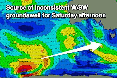
Longer term some small, inconsistent mid-period W/SW swell is due on the weekend, generated by a broad though distant frontal progression developing east of the Heard Island region.
The first pulse of swell for Saturday afternoon looks to come in at an inconsistent 1-2ft, with reinforcing pulses to 1ft to occasionally 2ft due through Monday and Tuesday. Winds will be best on the weekend and N/NE tending E/NE Saturday with N winds ahead of a trough and S change Sunday. More on this in the next update though.

