Lots of surf from Friday
Southern Tasmanian Surf Forecast by Craig Brokensha (issued Wednesday December 21st)
Best Days: Friday morning, Saturday morning, Sunday morning, Monday morning, Tuesday morning, Wednesday
Features of the Forecast (tl;dr)
- Tiny tomorrow with N/NE tending E/NE winds
- Small inconsistent W/SW groundswell Sat with variable tending S/SE winds
- Easing swell Sat with W/NW winds ahead of sea breezes
- Small W/SW swell Sun with N with sea breezes
- Moderate sized W/SW groundswell building rapidly Mon with variable tending SE winds
- Easing swell Tue with N/NE tending SE winds
- Easing Wed with N/NE winds
Recap
Clean but tiny surf yesterday, similar today with micro 0.5-1ft sets.
This week and next week (Dec 22 - 30)
Tomorrow will remain tiny, and winds will be fresh out of the N/NE, shifting E/NE into the afternoon and strengthening.
Later in the day we may see some inconsistent W/SW groundswell arriving but this will fill in Friday and peak through the middle of the day.
It’ll be inconsistent thanks to the frontal progression generating it forming in the Heard Island region. We should see 2ft+ sets across Clifton and winds are looking better, with a trough that was due to bring onshore winds now due to be weaker. This will result in variable winds ahead of S/SE sea breezes.
Saturday morning should still be 2ft but easing and winds will be offshore from the W/NW ahead of weak sea breezes.

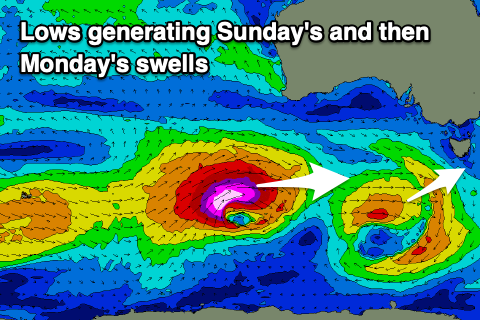
Into Christmas day, we’re now looking at a fun W/SW swell, generated by a tight though healthy low pushing in from the west tomorrow.
A fetch of strong to at times gale-force W/SW winds will produce a fun 2ft of swell that’s due to peak late morning through the afternoon. Winds look great and out of the N’th ahead of afternoon sea breezes.
Now, as talked about in Monday’s update, a significant, ‘bombing’ low is forecast to form to the south-west of Western Australia during the end of the week. A ‘bombing’ low is one which drops at least 24hPa within a 24 hour period and this will do so during Friday as a tropical depression gets dragged down into the westerly storm track from Madagscar.
As a result, we’ll see a significant fetch of storm-force W/SW winds projected through our western swell window.
This should fill in rapidly on Monday, building to 3-4ft across Clifton by early afternoon, peaking into the evening and then easing from 3ft on Tuesday morning.
Conditions will be clean Monday morning with variable winds ahead of sea breezes, then great Tuesday morning with a N/NE offshore ahead of sea breezes. Following this smaller surf is due into Wednesday with N/NE winds, giving into a trough and onshore change Thursday. More on this Friday.

