Poor weekend, small waves early in the week
Southern Tasmanian Surf Forecast by Craig Brokensha (issued Friday December 16th)
Best Days: Monday morning, Tuesday morning
Features of the Forecast (tl;dr)
- Moderate sized SW groundswell for later today, peaking tomorrow with strong S/SW tending S winds
- Easing surf Sun with moderate S/SE winds, strengthening
- Fading surf Mon with N/NW tending S/SE winds
- Small new SW swell Tue with variable tending S/SE winds
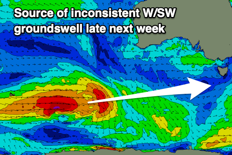
- Moderate sized, inconsistent W/SW groundswell for next Fri with S winds
Recap
A continuation of poor wind and weather with no major size across Clifton.
A new SW groundswell is due to build later today but with those poor winds. It's just been picked up on the Cape Sorell spectra so is on the way..

New SW groundswell inbound
This weekend and next week (Dec 17 – 23)
The weekend will remain a write-off with strong S/SW tending S winds tomorrow, weaker Sunday and only moderate from the S/SE, but after all the onshore wind, not great.
Later today's SW groundswell which was generated by a great polar low should peak tomorrow morning to 3ft+, easing and then dropping further from 2ft on Sunday.
Monday looks smaller and back to 1-2ft at best when winds finally relax, tending light N/NW ahead of S/SE sea breezes.

A small, weak front passing under us Sunday should generate a small, reinforcing S/SW swell Tuesday morning to 1-2ft and conditions will be clean again with a variable breeze, strengthening from the S/SE into the afternoon.
Following this Clifton looks to become tiny ahead of a new W/SW groundswell Friday.
This will be generated by a distant but strong polar frontal progression firing up around the Heard Island region, pushing east while slowly weakening. It looks to generate 2ft to occasionally 3ft waves across Clifton but the only issue is the local winds.
A trough may bring strong S winds, spoiling it. We'll have a closer look at this on Monday. Have a great weekend!

