Poor winds until next week
Southern Tasmanian Surf Forecast by Craig Brokensha (issued Wednesday December 14th)
Best Days: Monday morning for the desperate
Features of the Forecast (tl;dr)
- Small-mod sized mix of SW and S swells tomorrow, easing Fri
- Strong S tending S/SW winds tomorrow, strong S/SW Fri
- Moderate sized SW groundswell for Fri PM, easing Sat AM
- Strong S winds Sat, fresh S/SE Sun
- Fading surf Mon with variable tending SE winds
- Tiny swell Tue with SW tending SE winds
Recap
Clean though tiny surf yesterday morning, deteriorating into the afternoon with sea breezes.
A stronger trough brought in rain, cold weather and S'ly winds yesterday evening with a poor quality windswell breaking across the South Arm today to 2-3ft.
This week and next (Dec 15 – 23)
Settle in, as we're set to ride this run of poor wind, weather and surf right through the end of the week and weekend, with an improvement due into next.
The surface trough linked to yesterday evening's change is now deepening into a low pressure system to our east and will remain there through the end of the week before starting to shift a little east on the weekend.
This interaction between the low and a strong high to our west will bring strong S'ly tending S/SW winds tomorrow, strong S/SW breezes into Friday, shifting to the S'th on Saturday.

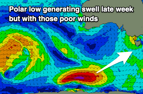
Besides localised windswell, a good SW groundswell due into Friday afternoon and Saturday morning will be spoilt, with it generated by a strong polar low that's currently moving in from the west. This swell should offer 3ft+ sets but with those poor conditions.
Unfortunately gusty S/SE winds will persist as the swell eases into Sunday, with Monday morning finally likely to offer variable morning winds.
By this time the surf looks to be 1-2ft max and on the ease.
Longer term we've got small to tiny levels of swell for the rest of next week from persistent but weak polar fronts moving around the southern flank of the blocking high sitting west of us. Winds look to swing more NE as the high slides east from Wednesday, though the swell looks to reach 1-2ft max. More on this in Friday's update.

