Onshore winds continue to create issues
Southern Tasmanian Surf Forecast by Craig Brokensha (issued Wednesday December 7th)
Best Days: Possibly Wednesday morning
Features of the Forecast (tl;dr)
- Building W/SW groundswell into the PM today with strong S/SW winds
- Easing W/SW groundswell Thu with strong SW tending S/SW winds
- Smaller Fri with strong S winds
- Fading surf Sat with W/NW tending SE winds
- Tiny W/SW swell Sun with freshening N/NE tending NE winds
- Building W/SW swell Wed with W/NW tending strong SW winds
- Bigger S/SW swell Thu with strong SW tending S/SW winds
Recap
Poor conditions with gusty onshore winds and a choppy windswell yesterday, while there was a window of cleaner, tiny leftovers this morning to 1-1.5ft. The windswelly nature of the swell can be seen in the screengrab below with the close-spaced sets.

Close spaced windswell leftovers this AM
This week and weekend (Dec 8 – 16)
This morning's window of lighter winds was just that, a brief window with conditions since deteriorating as another trough pushes up and into us.
It's spoiling a good new W/SW groundswell that's due into this afternoon and tomorrow morning, with inconsistent 2-3ft sets forecast for Clifton.
The trough is actually deepening into a low as it pushes across us, and this will kick up some local S/SW windswell tomorrow along with strong SW tending S/SW winds.
The low will stall to our east on Friday, keeping strong S winds blowing into the South Arm along with a mix of easing, weak swells.

We should see cleaner conditions develop on Saturday with a W/NW breeze but there'll unfortunately be no size left in the tank. Beginners should find a clean 1ft wave ahead of sea breezes.
Sunday will be clean in the morning with a N/NE wind ahead of strengthening NE breeze but the swell will be tiny out of the W/SW and to 1ft max.
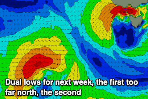
Moving into next week, we're due to see a mid-latitude low deepening up in the Bight, pushing east and to our north on Monday.
This looks to be too far north to generate any swell for us, but a secondary low at more southern latitude, pushing in behind the mid-latitude low should bring some new W/SW swell for Wednesday/Thursday, mixed in with close-range levels of S/SW swell Thursday as the backside of the low stalls under us.
Unfortunately due to the low stalling in our region we're due to see developing onshore W/SW winds on Wednesday as the low moves across us, SW tending S/SW on Thursday.
Size wise we should see surf in the 3ft+ range, but we'll have a closer look at this Friday.

