Plenty of swell but we're lacking an offshore wind
Southern Tasmanian Surf Forecast by Craig Brokensha (issued Monday December 5th)
Best Days: No good days
Features of the Forecast (tl;dr)
- Easing S/SE windswell tomorrow with strong S/SW winds
- Fresh to strong S/SW winds Wed with a building W/SW groundswell into the PM
- Easing W/SW groundswell Thu with strong SW winds
- Smaller Fri with gusty S/SW Winds
- Fading surf Sat with N tending SE winds
Recap
Great conditions but with a tiny leftover 1-1.5ft of swell Saturday, smaller again yesterday.
Today we've got a stormy increase in S/SE swell with strong onshore winds and nowhere to recommend.
This week and weekend (Dec 6 – 11)
The trough and low linked to today's poor conditions and onshore winds is moving slowly north-east and with this we'll see winds remain strong and onshore from the S/SE through tomorrow as the S/SE windswell slowly eases.
Unfortunately there'll be no reprieve from onshore winds moving into Wednesday as another trough approaches from the south-west, bringing S/SW winds that will be fresh to strong all day, stronger SW on Thursday as another trough moves through.

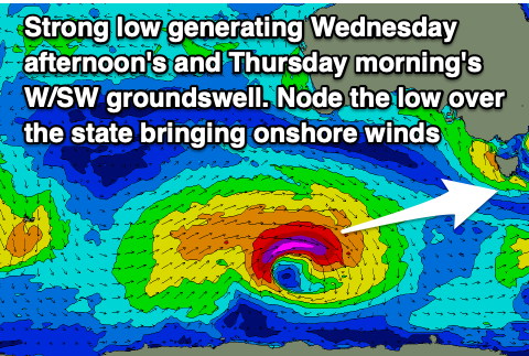
Swell wise, our new W/SW groundswell is due into the afternoon on Wednesday, generated by a strong low that's currently south-southwest of Western Australia.
We're seeing a fetch of severe-gale to at times, storm-force W/SW winds being projected east and this should produce 2-3ft of W/SW groundswell for Wednesday afternoon, easing from a similar size on Thursday morning.
Unfortunately those strong SW winds will continue to create poor conditions on Thursday, S/SW Friday as the swell continues to ease.
Following this there's nothing major on the cards at all unfortunately with cleaner conditions Saturday but tiny, easing surf from 1ft+.
More on this Wednesday.

