Strong swells inbound with plenty of size
Southern Tasmanian Surf Forecast by Craig Brokensha (issued Monday November 28th)
Best Days: Late tomorrow, Wednesday morning, protected spots Thursday afternoon, Friday, Saturday morning
Features of the Forecast (tl;dr)
- Moderate sized, mid-period W/SW swell building tomorrow with fresh W/SW-SW winds, tending W/NW late
- Moderate sized SW groundswell for Wed, easing later with N/NW-N winds, shifting W/SW late AM
- Moderate-large SW groundswell for Thu, peaking in the PM with W/SW-SW tending S/SW winds
- Easing swell Fri with N/NE winds, increasing
- Fading surf Sat with N tending E/NE winds
Recap
Inconsistent but fun, clean 1-2ft waves Saturday, tiny into yesterday and a rest day.
This morning we've got a new mix of swells coming in at 2-3ft with favourable winds that have remained so into this afternoon.
This week and weekend (Nov 29 – Dec 4)
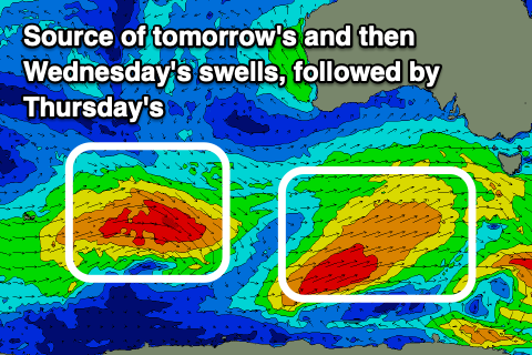
Today's first mix of swells is just the first in a series of bigger, stronger swells due through the coming week as we see the Southern Ocean firing up to our south-west.
 Today's all day offshore winds are linked to a strong, elongated frontal system approaching from the west, with a fetch of W/SW-SW winds being generated in our western and south-western swell windows.
Tomorrow should see mid-period W/SW swell energy building steadily through the day and reaching 3ft+ into the evening across Clifton along with gusty W/SW winds. We will likely see winds revert back to the W/NW into the evening and this will be the best time to surf.
Some better groundswell is due on Wednesday morning, generated by the strongest of the winds at the tail of the progression currently moving in from the west.
This should provide 3-4ft sets across Clifton and winds will be offshore from the N-N/NW until later morning when a W/SW change will move through.
Now, this change will be linked to a stronger, more intense low pusing through our swell window and under us Wednesday evening.
 This low has been upgraded in strength with a fetch of severe-gale to storm-force W/SW winds due to generate a large, long-period SW groundswell for Thursday, peaking into the afternoon.
We should see Clifton build to 4-5ft+. The easing trend looks steady, with easing 3-4ft waves on Friday morning, fading from 1-2ft on Saturday.
Winds on Thursday unfortunately look onshore and from the W/SW-SW tending S/SW through the day, clean Friday morning with a N/NE offshore, increasing through the day.
Longer term we've got small swells due into next week but with tricky winds. More on this Wednesday.

