Easing surf with cleaner conditions, active into next week
Southern Tasmanian Surf Forecast by Craig Brokensha (issued Wednesday November 23rd)
Best Days: Tomorrow morning, Friday morning, Saturday morning, Monday morning, Tuesday morning, Wednesday morning next week
Features of the Forecast (tl;dr)
- Easing S/SW swell tomorrow with W/NW tending W/SW late AM, strengthening
- Fading surf Fri with NW tending W/SW then S/SW winds
- Weak W/SW swell for later Fri with a slightly better SW swell Sat with N tending strong E/NE winds
- Good sized SW groundswell for Sun PM with N/NW tending SW winds
- Steady SW and W/SW swell Mon with N/NW winds
Recap
Great conditions with 2-3ft of swell yesterday morning before a stronger change moved through just before 10am. The swell kicked further in size through the afternoon but today we've seen a peak in energy with large 6ft+ sets reported, now easing. Protected spots were best but now are poor with a devil wind and cleaner conditions across Clifton with a drop in size.

Chunky and clean this afternoon
This week and next (Nov 24 - 27)
The strong polar front linked to today's large swell is moving off to the east and with this, we've seen winds swing back to the NW this afternoon.
 The swell is due to ease considerably overnight, dropping back to 2-3ft tomorrow morning out of a more southerly swell direction and then a smaller 1-2ft on Friday.
Winds will be good tomorrow morning and out of the W/NW, shifting W/SW late morning and strengthening. So surf before then.
Friday looks to play out similar wind wise but with a morning NW breeze ahead of W/SW tending S/SW winds into the afternoon.
A small pulse of weak W/SW swell is due into the afternoon, with a better pulse of SW energy on Saturday, produced by a weak low that's currently south of Western Australia.
 A pre-frontal fetch of W/NW winds looks to generate a weak 1-2ft wave for late Friday but with the onshore wind, a little better Saturday with 1-2ft surf continuing under a N tending strong E/NE breeze.
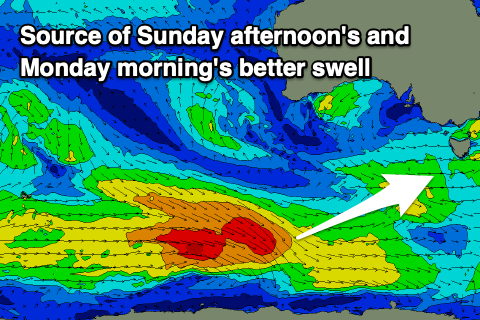
Of greater importance is stronger, more favourably aimed and better polar frontal activity moving in through this evening and tomorrow. A fetch of sub-gale-force W/NW winds should generate a fun SW groundswell for Sunday afternoon to 2ft+, while some close-range swell to a similar size looks to maintain wave heights Monday. Winds on Sunday afternoon look SW, cleaner Monday and out of the NW, but we'll review this Monday.
Following this there's plenty more polar frontal activity on the cards, if not stronger, bringing larger surf next week. More on this Friday though.

