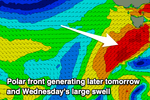
Building surf and increasing wind
Southern Tasmanian Surf Forecast by Craig Brokensha (issued Monday November 21st)
Best Days: Early tomorrow, protected spots late but more so Wednesday, Thursday morning, Friday morning
Features of the Forecast (tl;dr)
- Moderate sized mid-period SW swell for tomorrow with early N/NW winds, tending W/SW late AM and strengthening into the PM and evening
- Larger SW groundswell building late tomorrow, peaking Wed AM with strong W/SW-SW winds
- Easing S/SW swell Thu with W/NW tending W/SW winds
- Smaller Fri with NW tending S/SE winds
- New small W/SW swell for later Fri, peaking Sat with strong N/NE winds
- Inconsistent SW swell for later Sun, peaking Mon with W/NW winds
Recap
Clean conditions with some fun 1-2ft waves Saturday morning, poor yesterday with choppy conditions ahead of a better offshore change but tiny swell.
Today the swell has come up a touch with clean conditions in protected spots ahead of a SW change this afternoon.
This week and next (Nov 22 - 27)
Currently a strong cold outbreak is moving across the state, bringing this afternoon's change and cooler weather.
We're seeing a fetch of strong SW winds projected up and into us and this will generate a moderate sized mid-period SW for later today but more so tomorrow ahead of an even larger SW groundswell into late tomorrow, peaking Wednesday morning.
 This larger groundswell will be produced by a significant and strengthening polar front being drawn up and into us this evening and tomorrow, with a fetch of SW gales being generated.
Size wise, tomorrow morning looks to come in around 3-4ft, kicking later to 4-6ft with Wednesday morning easing back from the 6ft range.
Winds will be strong for the most part but there's a window of lighter N/NW breezes tomorrow morning ahead of a strong W/SW change late morning, increasing through the afternoon. Wednesday will then see strong W/SW-SW winds, easing a little into the late afternoon/evening.
Moving into Thursday a morning W/NW breeze should be seen in the morning (W/SW afternoon) along with easing levels of S/SW swell from 2-3ft.
Into the end of the week a small mid-period W/SW swell is due Friday afternoon and Saturday morning to 1-2ft, generated by a weak low moving in under the country over the coming days.
Of greater importance is a stronger polar front following this, generating a good SW groundswell for Sunday afternoon and Monday morning with sets to 2ft under a W/NW breeze. This looks to be a better swell producer compared to Saturday's but we'll have a closer look at this on Wednesday.

