Fun swells, tricky winds
Southern Tasmanian Surf Forecast by Craig Brokensha (issued Wednesday November 9th)
Best Days: Selected spots tomorrow and early Friday, Tuesday morning
Features of the Forecast (tl;dr)
- Fun sized SW swell for tomorrow and Fri, easing on the weekend
- Strong N/NE-NE winds tomorrow, N/NW early Fri ahead of a weak S/SE change mid-late AM, stronger S/SW into the PM
- Moderate S/SW tending S/SE winds Sat
- Strong NE winds Sun
- Moderate sized mid-period SW swell building later Mon, peaking Tue with possible early N/NW winds ahead of a S/SW change
Recap
Clean conditions and fun 1-2ft waves both yesterday and this morning, choppy into the afternoons with sea breezes.
This week and next (Nov 10 - 18)
Looking at the coming days, and we've got our better pulses of mid-period and then SW groundswell due to fill in tomorrow, peaking through the evening ahead of a drop in size Friday.
The source of these swells was a strong polar low that formed in our far swell window on the weekend, generating a fetch of W/NW and W/SW gales before weakening while slowly pushing east over the past couple of days.
The remnants of the low are now below us, and we should see good 2ft+ surf through tomorrow and Friday with the chance of the rare bigger one.
Winds will strengthen from the N/NE-NE tomorrow, creating poor conditions across Clifton, with selected locations fairing better.
 A change is due later morning Friday, with early, lighter N/NE winds ahead of it, then shifting S/SE ahead of a stronger S/SW burst into the afternoon.
The trough responsible for this change will feed into a low strengthening to our north-west, with it dropping south-east towards us on the weekend.
This will unfortunately leave moderate S/SW tending S/SE winds into Saturday, shifting NE but with strength on Sunday as the swell from Friday fades.
Options will be limited with easing surf from 1-2ft Saturday, tiny Sunday.
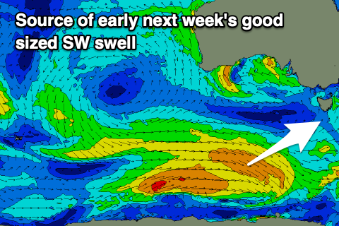
Moving into next week, we've got a good sized SW swell due to build Monday afternoon, peaking Tuesday, generated by a healthy polar front moving in from the west over the coming days.
The only issue is that the mid-latitude low drifting south-east towards us on the weekend looks to bring a SW change Monday afternoon. Possibly tending back NW temporarily Tuesday morning ahead of stronger S winds.
Size wise, the swell looks to come in around 3ft but we'll have to have a closer look at this on Friday.

