Plenty of swell to come as winds freshen
Southern Tasmanian Surf Forecast by Craig Brokensha (issued Monday November 7th)
Best Days: Tomorrow morning, Wednesday morning, Thursday selected spots, early Friday selected spots, Sunday selected spots
Features of the Forecast (tl;dr)
- Small mid-period SW swell for tomorrow and Wed with N tending gusty E/NE winds
- Fun sized mid-period SW swell for Thu and Fri, with a few stronger groundswel sets Thu PM and Fri
- Strong N/NE winds Thu and Fri AM ahead of a S/SE change mid-late AM
- S/SW winds Sat with easing surf, smaller Sun with NE winds
- Moderate sized SW groundswell for Mon with a developing S/SW change
Recap
Our solid and upgraded S/SW energy for Saturday came in at a good 3-4ft across Clifton but conditions were only OK early with a variable breeze before onshore winds kicked in. Yesterday was a little smaller but cleaner and easing from 3ft, a better and fun 2ft today.
This week and weekend (Nov 8 - 13)
We've got an active fortnight of surf ahead as the Southern Ocean continues to produce favourably aligned storms in our swell window.
A small, reinforcing mid-period SW swell is due tomorrow, generated by a weak polar front currently south of us. This should maintain 1-2ft sets tomorrow and Wednesday morning with light morning N winds ahead of gusty E/NE sea breezes.
Moving into the end of the week, and we've got a good mix of moderate sized, mid-period SW swell, with some slightly better period stuff due into the afternoon Thursday, holding Friday.
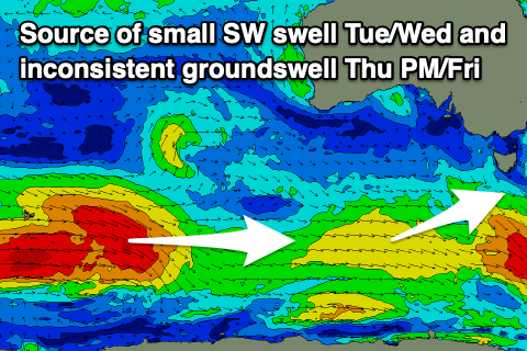
 These swells are being generated by a slightly stronger polar frontal system that's currently south-southwest of Western Australia.
Yesterday, this front was generating gale-force winds in our far swell window, but it's now weaker and will continue to decay while tracking east today and tomorrow. This will result in mid-period energy arriving Thursday morning ahead of the stronger, more groundswelly sets into the afternoon and Friday.
Thursday morning should be a fun 2ft+, with similar sized surf due Friday but with a bit more power expected to the sets from Thursday afternoon.
Winds will strengthen from the N/NE on Thursday, favouring selected spots, while Friday will see a trough move through with early N/NE winds due to swing S/SE and strengthen mid-late morning.
Unfortunately the trough looks to linger to our west, possibly forming into a low, bringing persistent S/SE winds on Saturday, that may shift more NE on Sunday.
We've got another good sized swell due into early next week, generated by a healthy polar low developing south of the country later this week and weekend. At this stage this looks to be bigger than the swell late this week, with sets to 3ft due across Clifton though another trough may bring a S/SW change. We'll have a closer look at this Wednesday.

