Lots of fun surf available most days
South Arm Surf Forecast by Ben Matson (issued Friday 4th November)
Features of the Forecast (tl;dr)
- Easing surf Sat with generally light winds (tending SE'ly at times)
- Another strong groundswell late Sat/Sun, with generally light winds
- Easing surf from mon, persisting small and fun from Tues-Thurs, then another slightly bigger pulse due Fri
Recap
Plenty of surf over the last few days with size around 3ft across the South Arm and generally light winds.
This weekend (Nov 5 - 6)
We’ve got some more great waves due over the weekend.
A weak high pressure ridge will maintain a light variable flow across the region, though it will tend south-easterly inshore at times, which will have a bearing on surf quality. I'm not expecting much strength though.
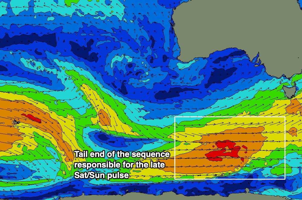
Today’s strong swell is expected to ease a touch into Saturday morning, ahead of a renewal of long period energy into the afternoon, generated by a strong fetch at the tail end of our recent Southern Ocean conveyor belt.
This activity looks really good on paper, though I’m cautious of suggesting any more size than we’re seeing today, as the source storm track was/is somewhat unusual: starting off as a broad belt of off-axis N/NW gales to the south-east of Madagascar, before strengthening a polar low and front along the ice shelf as it tracked below Western Australia, and exiting our swell window today as a broad westerly flow under South Australia (see below).

That being said, it's a really strong, sustained storm track at lower latitudes, which will allow it to organise into really well defined swell lines once it filters into Storm Bay (also, it's uncommon for such swells to be accompanied by light variable winds, so that's a big positive).
The reduced confidence lies in projected surf heights, as the models are focusing the longer period energy into SA (rather than Vic/Tas) which is attenuating predicted surf size.
So, enough waffle - let’s fly some numbers.
I’m expecting today’s swell to ease back a little by early morning, say 2-3ft sets across the South Arm, ahead of a late afternoon pulse that will will show best overnight and early Sunday morning, pushing 4ft at the South Arm swell magnets. Size will then ease slowly through the day.
Next week (Nov 7 onwards)
Next week looks small but fun.
The broader outlook is for a continuation of generally high pressure over the state and light winds, tending fresh NE at times (later Wed/Thurs), along with back-to-back groundswells, source from polar lows. These storms are expected to be quite strong (great for swell potential) and well aligned for our region, but unfortunately they'll be most active in the far reaches of our swell window, which will temper wave heights across the South Arm due to significant wave decay.
So, expect a slow decrease in size from Sunday through Monday (early 3ft sets, easing to 2ft during the day), persisting in this size range Tuesday, before restrengthening in the 2ft+ range Wednesday, holding Thursday, ahead of a slightly bigger long period SW swell due around Friday that should nudge 2-3ft.
All in all, a nice spell of small clean surf for the South Arm, there'll be fun waves most days.
Get into it!

