Upgrade in swell next week
Southern Tasmanian Surf Forecast by Craig Brokensha (issued Friday October 7th)
Best Days: Sunday morning, Tuesday, Wednesday
Features of the Forecast (tl;dr)
- Small pulse of W/SW swell Sat PM with NW tending fresh W/SW-SW winds, easing Sun with NW tending SE winds
- Moderate sized SW swell Tue with N tending gusty E/NE winds, easing Wed with strengthening NE tending E/NE winds
Recap
The swell was still coming in at a good 2ft+ yesterday with workable winds for selected spots, back to the tiny stuff today and best for beginners.
This weekend and next week (Oct 8 - 14)
Looking at the weekend ahead and we've got some inconsistent, long-range W/SW energy due, mixed in with some more localised and more consistent SW energy from a small flukey low that's currently south-west of us.
The swell from this low has been downgraded due to the fetch being weaker and off axis.
 We should see a slow increase in size to 1-2ft tomorrow afternoon, easing from a similar 1-2ft on Sunday morning but with NW tending W/SW-SW winds tomorrow, best Sunday with a NW offshore ahead of SE sea breezes.
The swell will bottom out into Monday ahead of a fun pulse of mid-period SW swell on Tuesday.
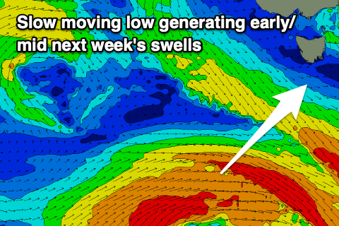
This will be generated by a healthy polar low forming south-west of us on Sunday with sets to 3ft across Clifton with a light N'ly offshore, shifting E/NE into the afternoon and strengthening.
The swell will be prolonged thanks to the slow moving nature of the low, with easing sets from 2ft out of the S/SW Wednesday with gusty N/NE tending NE winds.
Longer term there's nothing too major on the cards besides an inconsistent W/SW groundswell for maybe next weekend. More on this Monday. Have a great weekend!

